Chris Kridler
Chris Kridler is a writer, photographer and storm chaser and author of the Storm Seekers Series of storm-chasing adventures.

Chris Kridler is a writer, photographer and storm chaser and author of the Storm Seekers Series of storm-chasing adventures.
I have extensive archives from my early storm chasing years. I chronicled almost every day on the road, even bust days, at the old SkyDiary site, with lots of photos. In the interest of collecting everything in one place, I’m moving the highlights of the older chases over to ChrisKridler.com. 2006 was one of the worst chasing years in pursuit of storms, thanks to a crashing cold front, but it had a few moments.
8 May 2006
Chase time: Just a quick update. After a 21-hour drive, I’m in Broken Arrow, Okla., and not quite in position to chase today. I’ll need to do my forecast and drive some more to get there, wherever there is, but at least I feel like I’m back in Tornado Alley again. I love what one sees on the road: two billboards next to one another, one warning of fire danger, the other covered with flames advertising a barbecue joint. A sign that says “Watch for long logs” (insert your own joke here). Another for Toad Suck Park in Arkansas. Watermelons galore sold out of the backs of pickup trucks in Mississippi.
Update: I tried but didn’t see much today. Storms didn’t fire where people thought they should, though a big line of them formed in western Kansas, and I got a look. There were some pretty moments and a few good lightning bolts. It’s something and was a good shakedown cruise for gear, including the new ham radio. I’ve now met up with Scott McPartland, Dave Lewison, Pete Ventre and Jim Edds. Given a promised early start in the morning, I anticipate more sleep deprivation in my future. Now we’re at a terrible Days Inn in Great Bend that promised wi-fi, and it’s not working. My ceiling is leaking in the rain. And goodness knows if there really will be a promised hot waffle in the a.m. More later…
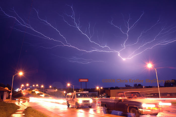
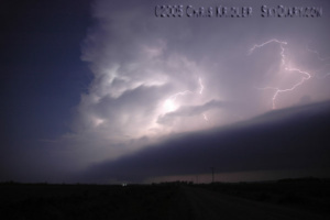
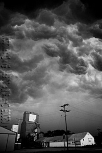
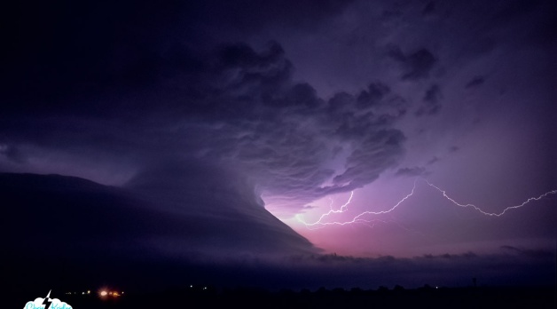
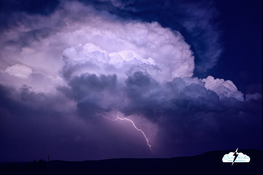
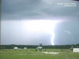
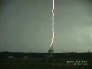
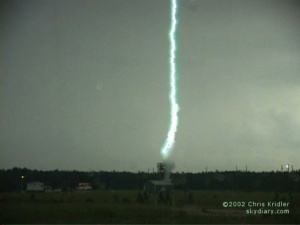
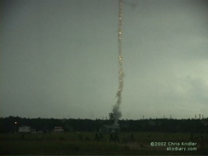
Lightning in McAlester, Oklahoma, May 9, 2006.
9 May 2006
The soggy and the sublime: After an unfulfilling chase yesterday, the hotel nightmare (even the advertised “hot waffle” was not the fresh-made thing you get at some hotels; it was a Kellogg’s toaster product), and continuing sleep deprivation, a chase finally was in the offing today. It provided some adrenaline and some pretty pictures, and that’s about all I can ask for.
Our party left Great Bend, Kansas, fairly early and headed south, checking data now and again to help us pick our target. The obvious choice was southeastern Oklahoma and the less obvious choice was north-west-central Texas. Finally, we settled on eastern OK. As half our party broke off north of Ada to say hi to Cloud 9 Tours, Jim Edds and I proceeded south and then east after getting a look at the towers going up in earnest on the boundary. It was imperative to get east, ahead of the line, or else it would be a day of core-punching. Not that we avoided cores entirely.
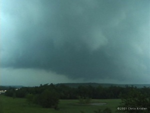
Mammatus and lightning in Oklahoma May 9.
In McAlester, we waffled (again with the waffles!) about which storm to pick. A tornado warning was given for the storm to the south, but ours still looked good. We were about to give up on it when it became tornado warned, too. Then, on the west side of town, we spotted what appeared to be a rotating wall cloud. For a moment, I was wondering if we were about to have a tornado form over our heads. Then winds picked up like crazy and we thought we’d try to get east of it. Bad idea, or at least a bad road choice, not that there are any good roads out here in the tree-heavy hills. We got caught in serious horizontal winds — I’d guess about 70mph — with flying debris, driving rain, very low visibility and hail. The core, in other words.
After more storm maneuvering and finding we’d be in the path of another tornado-warned storm, we slipped west back into town and got some very cool lightning shots, Jim with his HD video, me with some video and a lot of stills. This good photo opportunity did a lot to make the day memorable. Now our party is back together, along with Dave Patrick and Kristy Randall, and Mark Robinson and his friend Brian. I’ve spent a lot of time in McAlester today. The problem for tomorrow is that the risk area is in more bad chase territory and way farther east than I prefer to go. Meanwhile, after that, the Plains may be shut down in terms of severe weather. Should I stay or should I go?
11 May 2006
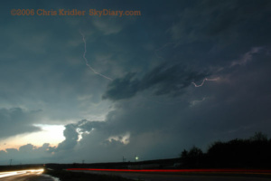
Mark Robinson films a storm May 10 as the season screeches to a halt.
The end already? I’m way behind on updates because of the lack of high-speed Internet and all the driving, which equals no time. We’re in Mississippi, for goodness’ sake. That’s not where we’re supposed to be to chase “Tornado Alley” storms.
We had a good target yesterday but were behind the game all day due to the long distances involved. We got wet and saw some lightning, that’s about it.
I’m actually giving it up for now and hope to come back to the Alley at some later date.
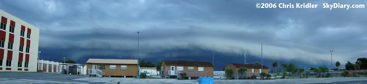
Shelf cloud in Rockledge, Florida, Sept. 2, 2006.
2 September 2006
A dramatic shelf cloud formed from a line of storms in Brevard County, Florida, on September 2. First, the pileus cap on top of the storm tower glowed in rainbow colors as the sun caught it from behind. Then the shelf appeared. Here’s a stitched-together panorama of several images of the shelf cloud as seen from Rockledge, Florida.
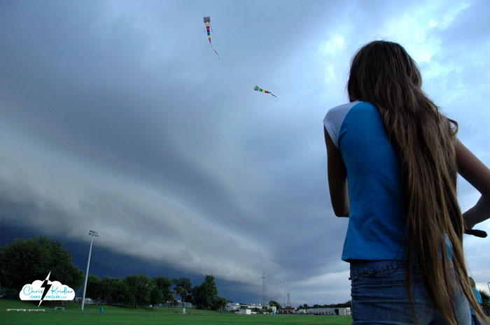
Kids fly kites before the storm, Sept. 2, 2006.
A couple of neighborhood kids were flying kites at the high school ahead of the storm. This is not recommended behavior in a lightning storm, but it was kind of beautiful.
I have extensive archives from my early storm chasing years. I chronicled almost every day on the road, even bust days, at the old SkyDiary site, with lots of photos. In the interest of collecting everything in one place, I’m moving edited journals and highlights of the older chases to ChrisKridler.com, with select photos to accompany them. Dates in the subheads are the dates of journal entries, not necessarily events.
The highlight of this account is the May 12 hail barrage and tornado at South Plains, Texas.
 May 6: Colby, Kansas
It’s been a long day, and tomorrow there’s a long drive ahead, so I’ll make this short. I drove west this afternoon from Hays to Goodland, Kansas, to get some data. My initial target was southwest Nebraska, with the thought that storms might form in eastern Colorado, just west of Goodland, and move northeast. It turns out the dryline was right there, and a few cumulus clouds were starting to bubble. The one that bubbled the most ended up being the storm I chased all day, right out of Goodland and up into Nebraska. It didn’t move fast, and despite wall clouds and a tornado warning, I didn’t see a tornado – though I did see a very well-formed scudnado (looks like one, but isn’t) that fooled me for a minute. Maybe someone in another position did see one, but the storm was rolling over a terrible road network, and I spent a lot of the day trying to pick the least muddy gravel road to traverse.
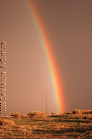
The best part of the day may have been the sunset, which shot yellow light over the rolling hills at the Kansas-Nebraska border and pulled a brilliant double rainbow out of the rain in the eastern sky, the full arch. Fantastic.
May 9: Manhattan, Kansas
It’s a quiet day in Kansas after a couple of fun storm chases. The night of May 6, I met up with the crew I chased with last year (Scott McPartland, Pete Ventre and Dave Lewison; and Mark Robinson, Dave Sills and a Toronto Star reporter), and on May 7, we set out for Kearney, Nebraska (joined by Dave Patrick and Kristy Randall of Ontario). That was our initial target, anyway.
We were almost there when storms started going off on the dryline to our west. We turned around and cruised back down the Interstate to intercept as the cells hauled north. They were pretty, even tornado-warned, but we didn’t see any tornadoes. By this time, cells were blossoming to our east, and back we went again, toward our original target in the better air, caught at one railroad crossing after another. Just west of Kearney, after another train went by, we made a right turn and saw a big, dark lowering under a tornado-warned cell. I was on the phone with hubby George at the time. “I have to call you back!” I said. We had a four-car caravan, and everyone figured we saw a tornaodo. Subsequent reviews of the tape and other reports appear to confirm it — but if you have to think about it too much, it wasn’t that great of a sighting.
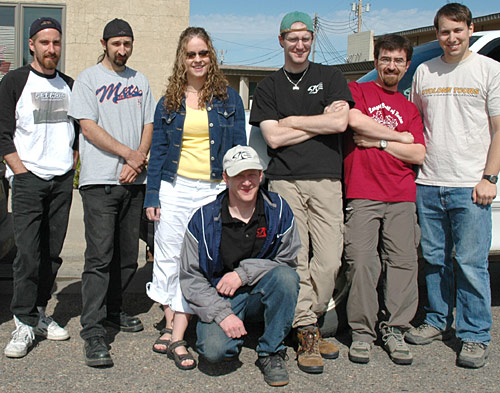
2005 chasing companions (from left): Scott McPartland, Pete Ventre, Kristy Randall and Dave Patrick, Mark Robinson, Dave Sills, Dave Lewison
The day actually got better from there. North of Grand Island, there was redevelopment on the back end of the storm, and we caught some pretty towers going up with scudding clouds in the inflow that the inexperienced might call a funnel. Meanwhile, there were plenty of the inexperienced around. All the locals were out for a chase. While we were filming the cell, a guy in a truck stopped in the middle of the road to tell us he’d just filmed a 20-minute tornado.
“Want to see it?” he said. “Not right now,” we told him. Um, we’re kinda busy, you know? Meanwhile, Mark Robinson’s car is a magnet for yahoos. It’s got about a zillion antennas, an anemometer, flashing lights, glaring decals. Scott McPartland’s car isn’t quite as obvious, but it also has a lot of gear on the roof and decals, along with a hail shield that Dave Lewison helped him build. Dave Patrick’s truck also has gear and a big lightning picture in the back window. So cars were following us all day … even into the network of muddy farm roads we then entered.
The roads were gravel and dirt, not too bad before it rained. But cells were passing through the area, including the ones we were chasing. We stopped on a hill and filmed a pretty orange sunset and a cell carved out by a rear-flank downdraft. Again, no tornado. I guess it was boring for the tagalongs as we hung out and took pictures, so they took off. I suggested we get moving before it got dark, because my Honda Element wasn’t thrilled with the roads.
As we got going, dusk was falling, and a new line of storms was headed for us. I noticed a young man walking along the road. He had a desperate expression and appeared to try to flag me down. I radioed Mark, who said they’d seen him, too. We decided to stop and see if we could help.
Lightning May 7.
May I just say, “Duh.” This was a carload of Grand Island locals, five young guys, who said they were following the storm and got lost. No, they were following US and got lost – and then slid their car into a ditch. We couldn’t even drive down the road they went down. A few of our guys walked into the lowering darkness to see if they could help push it out. They tried, unsuccessfully, while the cells got closer. Dave L.’s WxWorx satellite data showed “shear markers” in the storms, signs of rotation.
“We have to go NOW!” half our crew was shouting to the other half, who were down the hill in the dark, trying to get the car out. We ended up rearranging our passengers and carrying the five guys to the nearest town, Fullerton. Their car was left behind. Wicked storms trained over that area all evening … the car was probably door-deep in mud by the time it was over. We didn’t go back to find out.
Ominous “whale’s mouth” over Frankfort, Kansas, May 8.
South of Fullerton, we stopped and enjoyed a fantastic, strobing lightning show from the line of storms. It was like flash bulbs constantly going off, little sparks shooting through the clouds. We took lots of pictures and video, including shots of each other in front of the light show, a prairie Vegas.
May 8, we started out in Grand Island and headed east and south. We saw lots of storms, but nothing significant, except for a brief, well-formed funnel south of Washington, Kansas.
When it all merged into a fast-moving line, we got ahead enough to enjoy the “whale’s mouth” appearance, a roiling cathedral ceiling tumbling over itself, glowing with blue light. Then, for once, we had a relatively early night and grazed at the Sirloin Stockade in Manhattan, Kansas, for dinner.
Things should pick up tomorrow and might be really interesting Wednesday. It’s a matter of powerful dynamics coming together in a favorable way. Today, well, we might go see that crazy big ball of twine again.
“It sounded like a freight train” – Nebraska, May 10, 2005
May 13: Amarillo, Texas
Amarillo, Texas, is where I’m holed up while Band-Aids are put on my car after a good thrashing by hail yesterday (May 12). But let me backtrack a bit.
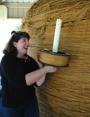
I was going to tell you about our stop in Cawker City, Kansas, a few days ago, when we actually got to add twine to the world’s largest ball of twine. Yes, the twine I added is now part of history, and I was pretty giddy with the excitement! And then I was going to tell you about a couple of subsequent chases … a powerful supercell in Nebraska that came painfully close to producing a tornado, but was mostly a fest of dusty spinups before becoming a stacked-plate behemoth after dark; and a frustrating Kansas chase that left us behind the storms in Nebraska and too far ahead of them in southwest Kansas – a day redeemed only by some nice lightning.
But instead of going on about all that, I’ll tell you about May 12.
May 12 is turning out to be a pretty significant day for me. Last year, I was with Dave Lewison, Scott McPartland and Pete Ventre that day, just east of the house destroyed by a tornado in Attica, Kansas. This year, I was with them, and Dave Patrick and Kristy Randall, in the Texas panhandle when everything went crazy. (Mark Robinson and Dave Sills had decided to chase in Kansas on their way home to Ontario.)
We started the day in Garden City, Kansas (where I stayed in the Best Western’s Presidential Suite for the single rate – Jacuzzi and everything!), and even though we knew we had what could be an impossible drive ahead of us, we decided Lubbock, Texas, was a good target. If anything went up along the front along the way, we could consider going after it.
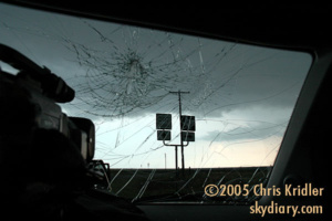
It’s almost a magical feeling, coming out from under the cold side of a weather front. Most of us don’t think about that kind of thing in our everyday lives, but when you know that there’s a boundary between two air masses, and you drive hundreds of miles to get from one side to the other, you’re very conscious of the vast changes going on around you. First, it was cloudy and cold, then eerily foggy. Then, it was suddenly warmer, with clearer skies above, and we saw the anvil of a tasty storm coming out of Plainview. Dave L. was able to track its growth using the WxWorx system that draws radar data from the XM satellites.
At a gas station, we ran into Tim Samaras and his pumped-up truck, loaded with off-road gear from a corporate sponsor. Some of you might have seen Tim featured on “National Geographic.” He’s a very nice guy. We said hello, and he told us to be careful. I think of that with irony now. (Of course, Tim deploys probes in the paths of tornadoes.)
So we got into the Panhandle, into the blocky, hilly geography of the Caprock, then west into the flatter areas of Quitaque and Silverton, and went south on 207. The first storm looked pretty good, and it formed a spinning wall cloud and rear-flank downdraft and looked like it was about to produce a tornado. It didn’t, but it was dropping baseball-size hail on chasers who tried to get north of it.
We decided to chase the southern storm, which looked promising visually and on radar. It followed about the same path. We went down a muddy farm road a little ways, but not far enough to get into trouble, and watched it evolve. This one’s downdraft kicked up dust, including distinct tornado-like spinups, and its wall cloud had some serious rotation. Our party was separated by a short distance on the farm road, but we all headed out toward the paved north-south road at about the same time to stay ahead of it.
As I started to drive south a bit farther, hoping to get south of it, it began to form a funnel.
Like almost everyone else – and there were a lot of chasers around, including tour groups – I pulled off to get some video and pictures. I realized there was big hail somewhere in there, but I also realized that I didn’t want to cross the road in front of it. There are a lot of “ifs” you consider later – if I’d kept going, I might have avoided the big hail, though I’d have no tornado video. Or if I’d kept going, I might have been munched by a huge tornado. In all, taking chances with the hail is probably smarter, though not much. (I suppose staying home is smartest.)
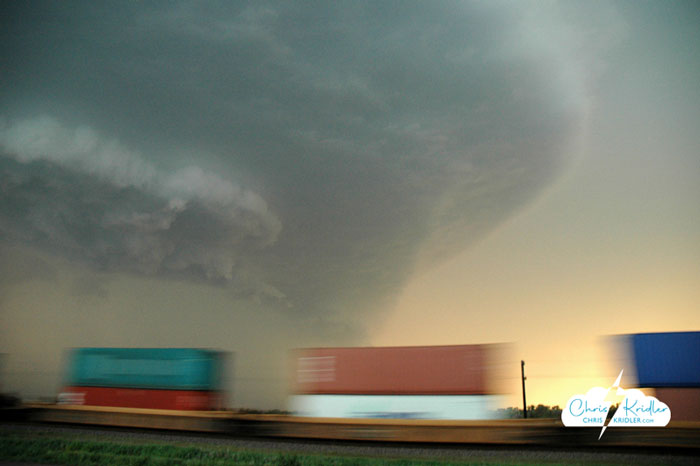
The South Plains (or Lone Star) tornado in two stages of its evolution, May 12, 2005.
Anyway, the tornado formed a beautiful white cone with a brown debris cloud flying around its base. It thickened, with condensation swirling in spirals around it, then darkened and grew as it got closer to the road.
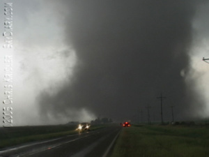
The tornado crosses the road south of my location.
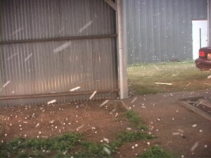
It crossed, with a huge, dusty circulation under the dark cylinder of the tornado. Dave L. warned over the radio from Scott’s car that we had to get out of there to avoid the big hail. But there was a big problem: The tornado had felled power poles, which were lying across the road. There might have been a way to squeak around, but by then we were in serious wind, rain and hail on the outer edges of the circulation, and then the big stuff started falling.)
This was one of those “lie back and think of England” moments, when you just have to resign yourself to the ravishing to follow. It’s like what they say about people on airplanes who know they’re going to crash – they don’t generally panic. And I had been through something like this before, in 2001. I naively thought this couldn’t get much worse.
It was. In 2001, my CR-V was hit by mostly golf balls and a few baseballs. This was mostly baseballs and a few softballs and grapefruits. It sounded like bowling balls were slamming into my roof. With some of those impacts, the entire car shook and the covers on my ceiling lights actually fell off. I was starting to worry that stones were going to come through.
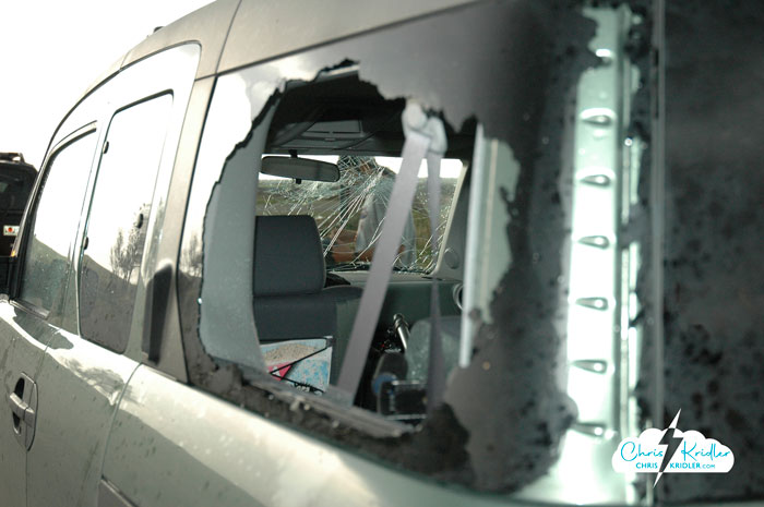
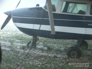
Hail shattered the Element’s windshield, among other things.
My windshield was whacked multiple times, with each impact creating a spectacular spider-web smash. A few little bits of glass fell onto the dash, but it held. Then I noticed I was getting hit by tiny bits of hail and rain. I couldn’t figure it out. Then I looked back. The side window in the back on my side was smashed in. I climbed back and stuffed a pillow in the hole to keep the worst of the stuff out. When the worst seemed to be over, we picked our way around the fallen power poles and headed south to get out of the precipitation and assess the damage. (And my pillow was lost along the way. I loved that pillow.)
So, in brief, the damage was … the two windows; a smashed-out taillight; huge dents that look like the product of a beating with a baseball bat; cracked plastic here and there; and my wounded psyche. At least that metal hail shield I’d ordered built for the sunroof was rock-solid. I can’t even imagine being in a storm like that with an unprotected glass sunroof. My car really would have been a hail-catcher (I talk about turning it into one sometimes; I’d have to armor it first).
A side window blown out by hail.
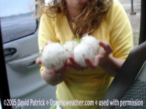
Kristy and Dave P. sampled the hailstones that got us.
One of Scott’s hail shields flew off. He had them for every window, but he lost a side window because he lost the shield. The chicken-wire hail shield he and Dave L. built to hang over the windshield preserved the window but had huge, bowl-like indentations in it from the hail strikes. Scott’s car also had body damage. So did Dave Patrick’s truck, and his windshield was hosed, too.
A lot of other chasers were caught. We ran into Cloud 9 Tours afterward. One of their side windows was blown out.
“Was there screaming in the van?” I asked.
“I was screaming,” a tourist from Liverpool said.
I don’t blame him.
This post is an update and remix of posts and images from my old SkyDiary website as I move chase accounts to ChrisKridler.com.
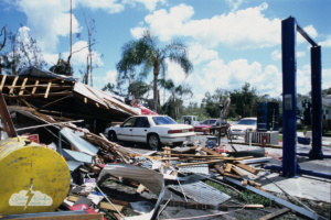
Damage after Hurricane Charley hit Punta Gorda Aug. 9, 2004.
I should say up front that I’m not a hurricane chaser. I find them fascinating, but I enjoy the visuals of supercells, tornadoes and lightning and loathe the misery hurricanes cause, given I live in the hurricane zone in Florida. And 2004 had plenty of misery to go around. While I didn’t experience Ivan, the third of four hurricanes that hit the state that year, I had more than enough fun with Charley, Frances and Jeanne.
Charley, which hit Punta Gorda on Florida’s west coast on Aug. 13, was a Category 4 at landfall. I almost chased it for the newspaper I worked for but changed my mind when I saw its rapid intensification – we literally turned around. I just wasn’t up for facing a Cat 4, especially for my first hurricane chase. But the next day, I was dispatched with a photographer to the area to document the damage. The eye was quite small, but its path was devastating.
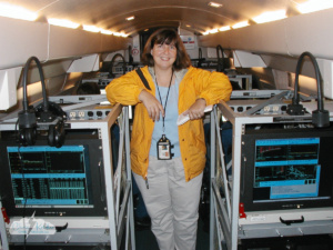
Chris on the all-night flight around Frances.
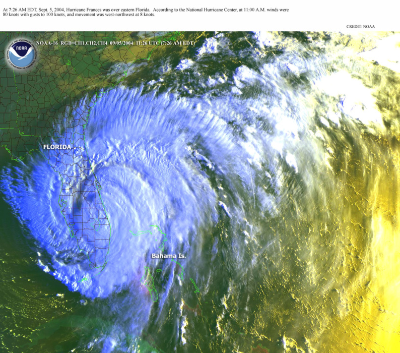
A couple of weeks later, as Hurricane Frances approached the Florida coast, the National Hurricane Center’s track at times brought it right into Brevard County, my home.
And I got the call that my name had come up on the waiting list to fly on NOAA’s GIV hurricane hunter plane, which flies around the periphery of the storm. So I drove over to Tampa to board the all-night flight and cover this unique perspective on hurricane research for my newspaper.
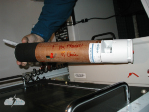
It’s tradition to sign the dropsondes, so I told the “F” storm what I thought.
The GIV crew plots a course that allows it to gather data that feed into computer models, aiding forecasting of a hurricane’s track and intensity. Dropsondes carry sensors that send data back to the plane before they fall into the ocean.
It’s tradition to sign a dropsonde – it looks kind of like a mailing tube – before it’s dropped from about 40,000 feet, so I was excited to sign one. I addressed the F storm, “F” you, Frances! <3, Chris.
The data are gathered and analyzed on the plane, then sent via satellite to the National Hurricane Center.
As we flew in the darkness, a report came through from the Air Force plane crisscrossing the eye: There, the moon shone.
“When you think of the houses it’s knocking down in the Bahamas right now, it’s not a pretty thing,” said Jack Parrish, flight director for the National Oceanic and Atmospheric Administration’s Gulfstream IV jet.
Remarkably, this flight was one of the calmest I’ve ever been on. This plane actually tries to avoid the roughest weather. (I still want to fly into the eye of a hurricane!) See more photos in the gallery below.
Frances whips up waves on the Indian River Lagoon.
As you can see in the photos below, S.F. Travis Co. in Cocoa, Florida, saw a big business selling generators and other supplies. Meanwhile, people lined up at Home Depot in Merritt Island to buy plywood so they could board up their windows. The 7-11 nearby was ready with its “Bring it on!” sign.
Surfers took advantage of crazy-high waves in Cocoa Beach on Sept. 3, before Frances made landfall late on Sept. 4.
The center of Frances ended up making landfall farther south from where I lived, and fortunately it weakened from a Cat 4 to a 2 at landfall, but the storm’s huge size and slow movement brought hours of strong, sometimes hurricane-force winds to Brevard.
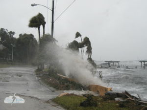
The wind whipped as the hurricane slowly churned inland. Hurricane-force winds rocked the Rockledge waterfront, kicking up surf on the normally calm Indian River Lagoon.
In the fierce winds and uncharacteristic waves on the lagoon, boats were bashed about and docks and dockhouses destroyed. Cocoa’s City Hall lost roof panels from its outdoor overhang. Many ended up across the street at Murdock’s restaurant and bar.
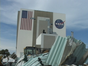
Damage to NASA’s Vehicle Assembly Building from Hurricane Frances.
Hurricane Frances also knocked over lots of large trees, causing power outages. That was fun – about five days of no air-conditioning. As you can see in one photo below shot in Rockledge, the tree pulled up the sidewalk with it.
Kennedy Space Center was blasted by the hurricane. The Vehicle Assembly Building, where space shuttle orbiters were stacked with their solid rocket boosters and external tank, lost 1.3 acres of wall panels. The shuttle tile and thermal blanket facility lost part of its roof.
Locally, the most stunning damage was to a Baptist church in Cocoa Beach. The steeple plunged through the roof and into the pews inside, like a missile. At least the congregation had a sense of humor about it; its sign afterward read “3 2 1 BLAST OFF.”
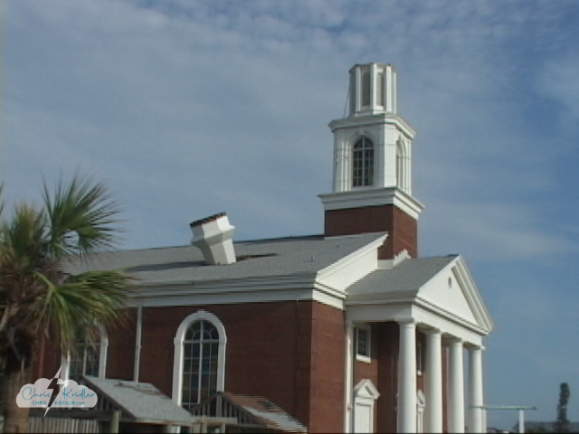
The First Baptist Church in Cocoa Beach lost its steeple in Frances.
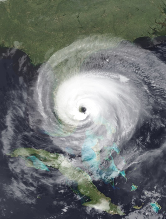
Hurricane Jeanne. Credit: NASA
Huge waves damage a boathouse in Rockledge, Florida, and push debris onto the shores of the Indian River Lagoon around 9 a.m. Sept. 26, 2004, as Hurricane Jeanne passed through.
Ivan actually preceded Jeanne, coming ashore Sept. 16, officially making landfall as a Category 3 at Gulf Shores, Alabama, with the Florida Panhandle helping take the brunt of the storm.
Jeanne made landfall in the same area as Frances, on Hutchinson Island on the eastern Florida coast, late on Sept. 25. We were without power for about 9 days for that one and it ruined my birthday, not that it’s all about me.
Unfortunately, it caused a lot of damage in Florida and, sadly, was responsible for deaths and billions in damage in the United States, though we’d been pre-disastered by Frances.
I think it’s safe to say that’s a season I never want to repeat.
Click on any image to start a slide show.
I’m reconstructing and enhancing this report ten years later as I move content over from the old SkyDiary website. This is still one of my most stunning chases. I only wish I’d had better gear and experience before I went into this day! But luck certainly had a hand in what we saw.
There was a lot of tough slogging in 2004 with few storms to chase in early May. After thousands of miles of driving over almost two weeks — which was about the span of my chasecation — and the bust of May 11, with its unfulfilled tornado watch, May 12 showed a lot of potential. And boy, did it pay off.
We started the day in Colby, Kansas. I drove Dave Lewison and me. With us were Scott McPartland and Pete Ventre in Scott’s car, and Mark Robinson, David Sills and Sarah Scriver in theirs. Our chase group (which Charles Edwards and others began to call “the Auto Club,” a la TWISTER) all agreed about southwest Kansas, though with variations on the exact target, from just east of Liberal on the Oklahoma border all the way to Dodge City and Pratt.
The Storm Prediction Center issued a slight risk of severe storms with a 5 percent tornado probability in our target area. The 1630Z discussion said:
..CENTRAL/SRN PLAINS…SLY FLOW HAS CONTINUED TO INCREASE GULF MOISTURE TO THE POINT WHERE THERE IS POTENTIALLY A VERY UNSTABLE AIR MASS S OF COLD FRONT AND E OF DRY LINE. A SUBSTANTIAL CAP WILL DELAY INITIATION UNTIL LATER THIS AFTERNOON. AS SURFACE LOW DEEPENS…SELY FLOW WILL INCREASE LOW LEVEL MOISTURE WWD INTO SERN CO. THIS WILL LIKELY BE AREA OF INITIAL CONVECTIVE DEVELOPMENT WITH ADDITIONAL STORMS ALONG COLD FRONT KS AND DOWN THE DRY LINE VICINITY OK/TX BORDER.
DEEP LAYER SHEAR OF 40-50 KT AND A VEERING HODOGRAPH IN THE SFC-1 KM LAYER..COUPLED WITH MLCAPES LIKELY IN EXCESS OF 3000 J/KG…SUPPORT A SUPERCELL MODE OF STORMS. PRIMARY THREAT WILL BE VERY LARGE HAIL HOWEVER AT LEAST ISOLATED TORNADOES ARE LIKELY IN AREAS OF ENHANCE LOW LEVEL CONVERGENCE AND SHEAR VICINITY DRY LINE AND COLD FRONT.
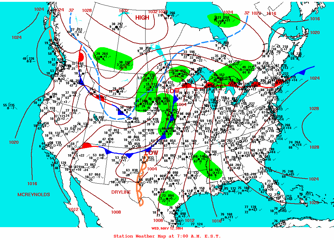
By 20Z – 3 p.m. central time – the discussion had updated with a greater tornado threat:
AIR MASS EAST OF THE DRYLINE HAS BECOME VERY UNSTABLE EARLY THIS AFTERNOON WITH MLCAPE BETWEEN 2000 AND 3000 J/KG ACROSS WRN AND CENTRAL OK INTO S CENTRAL KS. INTERESTINGLY…BRN SHEAR NUMBERS ARE 60-70 M2/S2 JUST ALONG/SE OF THE BOUNDARY AWAITING FOR THE WEAK CAP TO BREAK THAT IS STILL OVER CENTRAL OK. LATEST RUC MODEL INDICATES THAT CONVECTIVE DEVELOPMENT COULD OCCUR BY 00Z OVER CENTRAL KS…AND NEAR THE FRONT/DRYLINE INTERSECTION AFTER 00Z. POINT FORECAST SOUNDINGS INDICATE THAT BRN SHEAR VALUES WILL BE AROUND 80 M2/S2 INCREASING THE THREAT TO ISOLATED TORNADOES ACROSS EXTREME S CENTRAL KS/NWRN OK JUST EAST OF THE SURFACE LOW.
We stopped a couple of times to get data on the way, the last time in Meade. It was clear we were behind the dryline/front, with low dewpoints in the mid-50s. The storms would fire on the dry push bulging out east ahead of us, we were sure, and a few CU (cumulus clouds) were starting to go up there. Once we headed east and saw the small line starting to form, we were encouraged to see the kind of explosive convection we were longing for. One of the cells began to dominate, bubbling upward and outward in hard, white billows. Then a tower to its south began to swell, too, soon becoming a rival storm. It appeared the northern storm was splitting as we tried to reach them both from the west side, not the best way to intercept an east-moving storm. Plus, with the explosive upward development, we felt sure we would be tangling with some big hail as we tried to get through.
We stopped briefly on route 160, our road for most of the chase, and got a couple of shots of the hard anvil on the back side of the northern storm. Then we resumed our pursuit. We were starting to see storm chasers everywhere, as well as mobile Doppler radar trucks. Then, things started to get interesting. The storm to the north appeared to have some nice rotation at its base, possibly even a funnel. We heard that a storm spotter reported a tornado, though I didn’t see it. Mark and his crew dropped back to check it out. The rest of us were farther east, filming the northern storm, when I heard someone say over the scanner that there was a tornado. I was kind of puzzled, then saw the DOWs (Doppler on Wheels) and other cars screaming eastward. Dave L. turned around and saw that the storm to our south was producing a slim, white tornado.
It lasted several minutes, sending up a plume of red dust at its base. We knew we had to get east so we could catch the storm’s next cycle. Mark was unreachable by radio. There was nothing to do but go on. Dave and I went forward in my Honda Element, followed by Scott and Pete in Scott’s Nissan.
We hauled east to get into position.
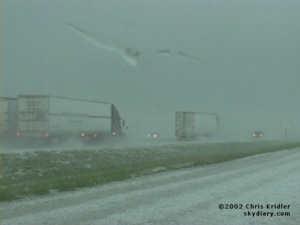
It was clear immediately that we were in for some stress, to put it mildly. First, there was a core to contend with, the part of the storm that contains most of the rain and, in the big boys like this one, the hail. Over the cell phone, our nowcaster, Jason Politte, suggested the core was mostly north of the road — but he could be off by a mile or two. Oh, boy!
There was a lot of rain, at first. Then the big hail started, golf balls and baseballs. Some of the baseballs were spiky. As we came into the town of Attica, Kansas, the sirens were screaming. I was making little fearful exclamations, as mentally I was reliving the 2001 hail-trashing of my CR-V. For about a block — literally, we circled the block — we tried to find a hail shelter, then realized that with the big, black mesocyclone to our south, we almost had to go on. Either we would sit there and get trashed by hail, possibly in the path of a tornado, or we would try to get out of the “hook” of hail wrapping around the rotating meso and also try to get ahead of the meso itself.
As we came out of town, we heard Charles Edwards of Cloud 9 Tours talking about a tornado over the scanner. It soon became clear that there was a funnel, with dust on the ground, as we got to the east edge of town. Now, which way to go? If we sat on the west side of the meso, we’d be crunched by hail and even more hail as the storm moved east, possibly blocking our view, not to mention trashing our cars. We chose, perhaps a bit unwisely, to go farther east.
This was a most amazing place to be. Not everyone chooses to chase a storm on the north side of a mesocyclone, since there is often hail (and believe me, there was – it’s a miracle we didn’t lose windows or have bigger dents), blindingly intense lightning like the bolts we saw, and, to make things worse, potentially north-moving tornadoes. We stopped directly north of the bulging funnel under the meso. Dust swirled beneath it. We could actually HEAR IT. A tornado doesn’t sound like a freight train when it’s not full of debris. It sounds like a waterfall. It was quiet, and beautiful, and scary. (The tense dialogue in the video is amusing in retrospect.)
The funnel elongated, then filled in. The tornado was moving our way. We zipped east, then got out of our cars for a few minutes to film it. Baseballs were still whizzing by us now and then. I actually put on my pith helmet (I almost keep it in the car as a joke for hail — but it was no joke this time).
Suddenly, Scott shouted that the tornado, now so huge it would not fit into our video frame, was going to hit a house on the other side of the road.
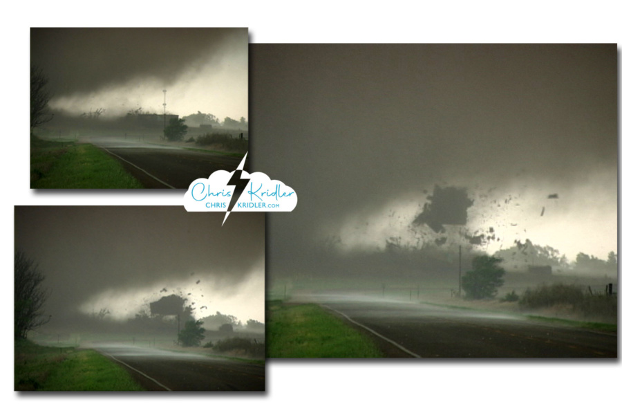
Three video grabs show the tornado tearing the roof off a house. We called a friend to notify emergency services as we got out of the way.
As we faced west, the tornado crossed the road, and the house seemed to explode in the ripping winds. The roof flew off and was sucked up. Debris flew everywhere, though not near us; we were less than a mile away. All of us were filming. We zoomed in on the destruction and caught it on video. The next day, we heard no one was inside, but we have since learned the family was at home and survived in the basement. Right after it happened, Dave called Jason to have him call in the event to the Harper County emergency services as we were not in a safe position to go back. The National Weather Service later reported, “This tornado was rated as an F2 due to the complete loss of the roof, two barns being destroyed and slight realignment of the vehicles.”
The tornado continued to spin north of the road, and the baseball-size hail was catching up to us. But this was a cyclic supercell, and it was about to do it again. We chose to continue east on 160. The meso stayed south of the road. I cried out that dust was already on the ground under it, behind a row of trees. It was the start of the next tornado.
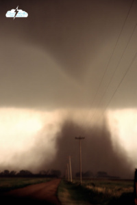
The third tornado of the day passes just to our south.
We got just north of this one, too, and parked in a tiny gravel road so that we could face it and videotape it. It formed an elegant funnel with a cloud of debris underneath, in a bright green field next to a red-earth road. It was backlit and looked almost black. It crossed some power lines, so gracefully, and suddenly, too close for comfort. We feared that it, too, would move north and on top of us. Time to move.
I turned left and sounded the alarm. A satellite tornado blocked our escape route, to the east of our cars, right on the road and coming our way! Satellite tornadoes can spin around the outside of the area of rotation and can move much faster than the main tornado. I put on the brakes, trying to figure out which way, if any, was safe to move. That tornado sort of evaporated while another satellite formed behind it, ripping into some trees, a thin but powerful swirl of red dirt. As soon as it moved off and dissipated, I hit the gas and we got the heck out of the bear’s cage.
Dave got some impressive footage of the main tornado — again, about a quarter-mile away — outside the passenger window as we sped east. Obviously, I couldn’t film that and drive at the same time. We turned north and paused to look back at the smoothly sculpted meso and tornado. The funnel was half-hidden in rain curtains. Hail fell around us, and lightning zapped nearby.
I was in full “flight” mode at this point after dodging the satellite tornadoes, but in retrospect, I wish we had stopped here a bit longer. The National Weather Service recorded F4 tornado damage just east of where we were at this moment. Though I’m not sure we would have seen the tornado even if we’d maintained a position north of it as precip got in the way and darkness encroached.
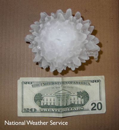 Our priority became getting out of the path. We also had to navigate out of the hail, so we headed east out of Harper. Check out this NWS photo of 5.24-inch hail from this storm!
On our way east, we saw a burning tree, the fire possibly caused by lightning. Later, we photographed lightning from a safe distance and met up with Mark’s party.
Things happened so fast, with so much adrenaline flowing, I was grateful for the video so I could review the sequence of events. And Dave made a great map reconstructing our route in conjunction with the tornadoes’ paths. The National Weather Service in Wichita documented 11 tornadoes in central Harper County on this day.
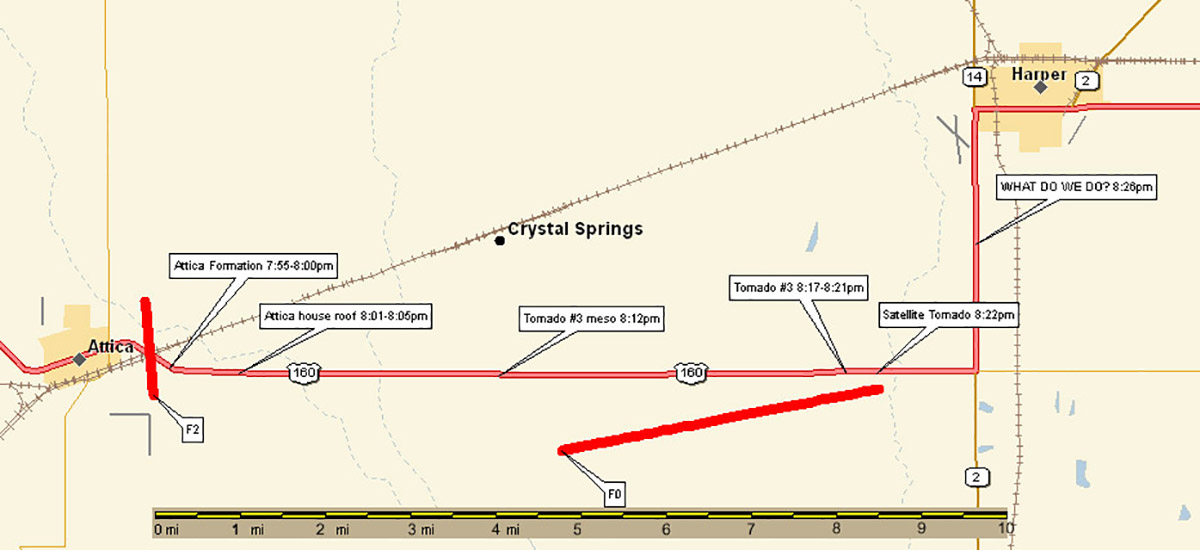
Map constructed by Dave Lewison of the Attica tornadoes and our timeline and path.
Click on any image to start a slide show. Note – in some cases these are video grabs from pre-HD video. The few slides I shot have that fuzzy retro feel partly because of the slow shutter speed. Ah, technology!
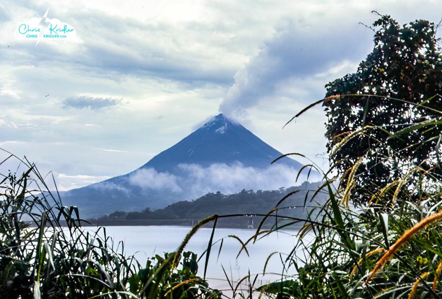
The Arenal volcano in Costa Rica on September 29, 2003 – shot on our honeymoon.
2003 was the chase that mostly didn’t happen.
The year 2003 was the most intense of my life. Ironically, none of that intensity came from storms, which have given me some of my most memorable experiences. I survived serious work stress, major foreign travel, a family crisis, and, on a pleasant note, my own wedding and an adventurous Costa Rica honeymoon.
 With the destruction of space shuttle Columbia on Feb. 1, my work life became a kind of hell. I was a space reporter for Florida Today, one of three. I covered the mission from Kennedy Space Center while the shuttle was still in orbit and before. I had interviewed the astronauts multiple times. I cared about the astronauts before the accident – most reporters didn’t even know their names. What followed was not only a sense of trauma and personal loss but an intense work schedule that involved countless hours, a trip to Houston, and, later in the spring, a trip overseas.
I was in Kazakhstan to see the launch of the Soyuz carrying the Expedition 7 crew to the International Space Station, and I was in Moscow for the landing of the Expedition 6 crew (off-course, and quite a source of suspense for a couple of hours).
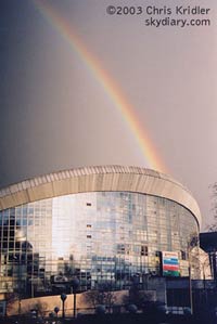
A rainbow forms over Moscow’s Olympic stadiums in spring 2003.
In the meantime, I was preparing for a wedding. There wasn’t a lot of lightning to chase in my part of Florida that summer, though I made a few attempts. We had a wedding picnic in a thunderstorm and a ceremony under a rainbow in September, a fitting touch, despite an almost stormless year.
I learned that as desperate as I was to see the storms, some things are more important, and sometimes life has other ideas. The important thing is to value the moments we have with the people we love. If fate is kind and persistence pays off, I’ll see storms again, and the chase will be as thrilling and fulfilling as ever.
Atmospherics at the windmill park at Shattuck, Oklahoma, on May 23, 2002.
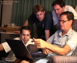
Chasers (from left) Dave Lewison, Mark Robinson and Bill Hark looked over Jim Leonard’s shoulder as he checked data on the Internet on May 19, 2002.
I have extensive archives from my early storm chasing years. I chronicled almost every day on the road, even bust days, at the old SkyDiary site, with lots of photos. In the interest of collecting everything in one place, I’m moving the highlights of the older chases – or quirky moments worth remembering – over to ChrisKridler.com. With that in mind, this post collects just a few of the accounts from 2002 and select photos to accompany them.
After one real chase on a really weak storm day, I’m exhausted. There’s been way too much driving and pizza over the past few days. But at least we were chasing today, despite marginal chances and marginal storms.
The first couple of days of the trip were spent sitting around in Norman, Okla., watching storm video with other chasers, reading technical manuals so I can learn to work my gadgets, and duct-taping things, including the toy Power Ranger on the front of my car (this is his third chase season).
The weather pattern has been rotten – one forecaster says it’s the worst for storms since 1987. Early in the month, when I wasn’t here, there was a great week, and then it all went to hell. Well, finally, a big storm system is pushing out the high pressure, but the moisture hasn’t yet returned from the Gulf of Mexico, and without moisture, there are no decent storms.
I’m chasing with Dave Lewison of New York state and Bill Hark of Richmond, Va. We’ve seen lots of tacky Americana so far, including the big Indian at the Cherokee Trading Post in Oklahoma and the giant Van Gogh sunflower painting in Goodland, Kansas, a hub of the sunflower industry. It sits on a giant easel in a dusty vacant lot and is about the size of a billboard, only vertical.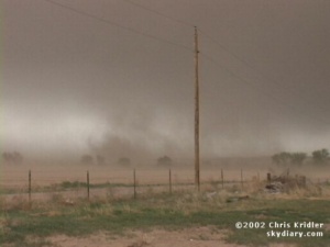
Today we headed northwest out of Goodland toward our target area in eastern Wyoming. Every time we stopped to take a reading, the anemometers showed higher and higher winds – 20s, 30s, 40s, 50-plus miles per hour. It was difficult to stand against it. Our clothes whipped around us, and the car was hard to handle as gusts pushed it all over the road.
And then there was the dust. Everywhere, it poured off the fields and into the air, streaming across the road, creating a choking haze of fine silt that got into everything – our hair, ears, eyes, cameras, car, clothes. The fierce winds punctuated each gust of dust with skittering tumbleweeds that seemed to float on the fields of wheat, bouncing across the waves, and then lofting across the road, sometimes nailing the cars in the process. The Dust Bowl must have been something like this.
By the time we got into eastern Wyoming, we’d had data and phone calls from friends and fellow chasers who told us what we didn’t want to hear: There were storms where we were headed, but they were weak. On top of that, they were almost impossible to see.
We decided to intercept one. After all, we’d driven all the way to Wyoming. We were in mountain time and everything.
At last, a storm loomed out of the haze, a great, mushy monster trailing virga – rain that wasn’t hitting the ground – and the raggedy edges we call scud clouds. It was linear, not spinning, part of a long line of storms that had formed a gust front, pushing walls of dust in front of it.
We played tag with the storm, watching it spin up gustnadoes – weak tornado-like spinups on the edge of the gust front – and even being hit by some. One piece of debris took out one of my antennas. We stopped briefly to put it back up. Another peppered us with tumbleweeds.
After yet another pizza dinner with some chasers from Arkansas and south Florida, we enjoyed a lightning show while driving an enormous number of miles, still being buffeted by fierce winds. We’re in position to head east tomorrow for more chasing – and, we hope, better chasing.
It’s been nine days since I’ve sent an update. This will be a more succinct summary, I hope, especially since there hasn’t been all that much fantastic weather to talk about. We’ve been driving all over creation, with not much to show for it.
On May 22, Dave Lewison of New York state, Bill Hark of Richmond, Va., and I ended up chasing storms that quickly evolved into a messy line, a story that was to repeat itself far too often. Yet, in Smith Center, Kansas, the tornado sirens went off and we saw what looked like a healthy wall cloud on the storm. We got out of the way of the supposed tornado – or tornadic circulation – but didn’t see anything too impressive.
May 23 was much better – in fact, the best chase day so far. We began the day with some good, old-fashioned Americana, the world’s largest hand-dug well in Greensburg, Kansas. Underground, there are stairs and platforms, several feet across. You can look in from ground level, outside the de rigueur gift shop. There was a honkin’ big tornado siren on top of the water tower right next to the well, and I hoped that would bode well for later in the day. The water tower was labeled, helpfully, “BIG WELL.”
By the time we checked data, we had just about given up hope. The atmosphere seemed contaminated by ongoing storms, cold and cloudy. But Bill got information after lunch that the atmosphere was clearing to the west, so we decided to play the dryline in the Texas panhandle.
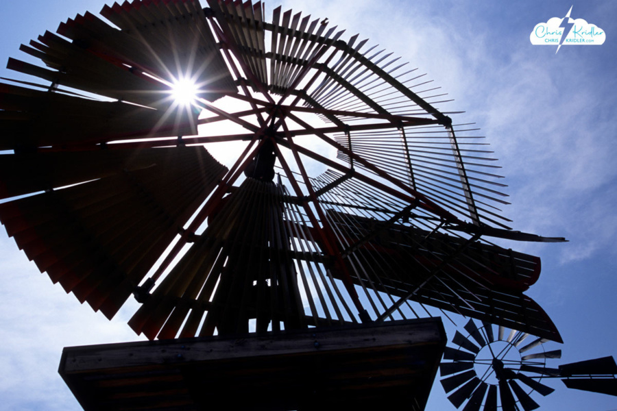
 On our way to the border, we stopped in Shattuck, Okla., where a mesmerizing park sprouts a number of old-time windmills, in a variety of designs. Every time the wind blows, there’s a haunting creaking and whispering from these beautiful mechanical trees, giant metal flowers that tower above the colorful wildflowers at their feet.
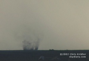
We noticed cloud towers starting to go up, so we broke off our tourist stop to head west. Over the border and into Texas, we waited, seeing other chasers as we went, watching the towers climb and topple until, finally, they broke through the cap. The explosion of convection was what we were waiting for, and we headed toward the storm.
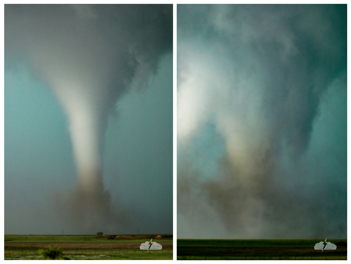
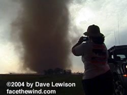
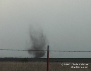
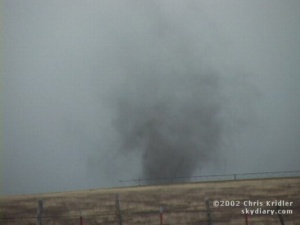
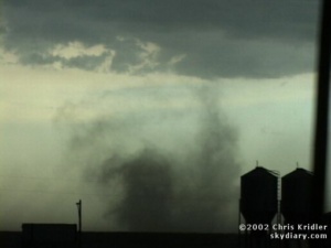
It was very high-based, thanks to the lack of moisture in the air, but it was rotating. To our surprise, it put down a dusty little tornado (landspout?). As we followed it, it put down about three more (pictured). At one point, we were literally across the road from the main area of rotation as it majestically spun itself into a large, sideways funnel shape and spun apart again, not quite ready to do it. Soon after that, the storm began to die.
We were hearing reports from nowcaster Jason Politte, an Arkansas storm chaser, of a much better storm near Borger, Texas, west of Pampa. The hitch: I had to be in Oklahoma City the next morning to play airport taxi. I reluctantly agreed to go after the storm.
On the way, we saw another storm that suddenly looked very impressive, with a wall cloud that looked like it was about to put down a tornado. Indeed, it did put one down briefly, as fellow chaser Scott Blair captured on videotape … though we couldn’t really see it. As the sun set, we left that storm and headed toward the Pampa one. Once we saw it, I had no doubt we had made the right decision. It was a beautifully sculpted storm; my one regret is that there wasn’t much light left to enjoy it. In fact, Bill captured a tornado under it using the low-light setting on his video camera, but it wasn’t visible to the naked eye.
The storm was sucking in 40-mile-per-hour inflow and spitting out amazing lightning. We watched it for some time, snapping pictures, before giving in to the late hour, a quick meal and a marathon drive back to Oklahoma City.
The storm near Borger and west of Pampa, Texas, had a significant wall cloud. The storm assumed an amazing structure as darkness fell as it spat out lightning.
The next morning, I picked up George Jenkins at the OKC airport. He’d never been chasing before, and I was hoping to show him some “good” weather – better than what we were used to in Florida – but the pattern still wasn’t all that cooperative. On May 24, our hopes for isolated supercells were dashed as messy storms again exploded all over the Texas panhandle and eastward. We briefly chased a storm with a tornado warning on it, then found out a short tornado occurred on another storm near the town where we were staying the night. The only thing that redeemed the chase was a pretty sunset and some pouchy mammatus clouds lit orange in the twilight.
The next day, we played tourist, exploring the magnificent Palo Duro Canyon south of Amarillo and eating steak with other storm chasers at the Big Texan that night, then watching each other’s video. Some of it was Scott Blair’s latest encounter with hail. Since he was with Dave and I during the trashing of my car during a hailstorm last spring, he’s been determined to take his core-punching to the limit. A couple of days later, he would smash his windshield further by driving into spiky, baseball-size hailstones.
May 26 brought several possible target areas. We decided to play the area where the dryline was pushing into the Oklahoma panhandle and southwest Kansas, but soon after we got on the storms coming out of southeast Colorado into the Oklahoma panhandle, it was the beginning of the end of our supercell hopes. The storm was filled with the green light that often indicates hail, and its forward edge started roiling. We realized it was gusting out, or becoming an outflow-dominant storm. In other words, it would not be a sustained supercell, but a blowout with high, unidirectional winds.
We kept up with it as it kicked up massive plumes of dust and saw some fantastic gustnadoes – tornado-like circulations that often form on the edge of a storm. Some of the gustnadoes looked meatier than the tornadoes we saw a few days before. Huge, rotating bowls of dust formed on the desolate plain. One gustnado crossed the road right in front of us as tumbleweeds bounced past.
W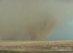 e were feeling cold outflow winds the whole time, and then, briefly, we got warm inflow, the sign that at least one part of the storm was still trying to stay alive by pulling in warm air from the east. About that time, a huge gustnado – could it have been a tornado? – spun up red dust in the field right next to us. The dust churned and rose, almost in a tube shape, to the edge of the storm clouds.
I had to split off from Dave for a day so I could take George back to the OKC airport. I was sad to see George go and also sad not to chase, but in keeping with the pattern, I didn’t miss all that much, stormwise. I was in a melancholy mood when I got to Abilene that night and met up with Dave, Bill and Jason Persoff of Jacksonville, Fla.
The four of us ended up chasing way into south Texas on May 28, maybe 50 miles from the Mexican border, and all for storms that were struggling to stay alive – though the lightning got incredibly hot and close at one point. To top things off, I hit a deer with my car – a glancing blow, but I’m sure the deer didn’t think of it that way. It shook me up as well. Fortunately, it hit the hail-dented side of my car, so it’s hard to notice the impact.
After sunset, our last storm began to weaken, but its snowy updraft – where the billowing clouds grew to meet the sky – spit out lightning as dusk fell. We ended the night joking around and looking at fireflies and the canopy of stars on the side of a rarely traveled road, among the mountains and mesas, where no artificial light polluted our view.
The storms were weak, but the universe is still spectacular. Even if we did have to eat a burger at midnight on the Interstate at Fort Stockton or go to bed hungry.
Since then it’s been goodbyes and relaxed traveling under sunny skies, hoping for the next storm system. Dave and I saw some bison today at the Wichita Mountains National Wildlife Refuge, relics of a past when there were 60 million of them roaming the Plains. Tonight, we joined the Cloud 9 Tours folks for dinner in Oklahoma City and saw the International Space Station go by overhead, a tiny dot of light. Later, a few of us went to a spot east of Norman where we could see an Iridium satellite flare at the precise time it went over our location, reflecting sunlight for one lovely moment in the dark sky.
I have another week of chasing ahead. At least, I hope it’s chasing … and not more suntan.
This is only my third and probably my last bulletin of this year’s low-key chase in the Plains. The only big events were before I arrived, but I’m sure there will be another big one after I go home.
Still, I got to see a few fun storms, the kind I would never see in Florida, and that’s why I’m out here. I also had a couple of close encounters with hail that convinced me I’m not quite over last year’s hail attack – the one that really messed up my car. Post-hail stress syndrome. I now have some dents on the “good” side, too, but they’re more subtle.
I had a couple of down days since I last wrote. On June 1, I went to the storm-chaser party at Rocky Rascovich’s house northwest of Oklahoma City, which was fun – the usual mix of burgers and amazing storm video. The highlight (admittedly, I left early so I could do another marathon drive) was Tim Marshall’s footage of the Happy, Texas, tornado in early May. In his footage of this monster, you can see the twister ripping roofs off.
Then Scott Blair from Arkansas and I drove our cars all the way to Kearney, Nebraska, to meet up with Jason Politte, also from Arkansas. The idea was to get into position for a chase the next day, which took us up into northeast Nebraska. Though there was a small cap – the warm layer of air that can keep storms from going up – we were optimistic that if a storm did occur, it would be a monster.
The only outbreak we got was of horseshoe vortices, the little horseshoe-shaped clouds that show there’s shear in the air. And I learned to play ground curling, a game Scott & Co. have played in the dirt on roadsides while waiting for storms. It’s a little like horseshoes, but more complicated. Usually you roll rocks, but road debris was permitted. I used a most excellent giant bolt.
After that, we had to drive some more – this time to western Nebraska, to get into position for the next day’s chase in eastern Colorado.
Hail core on June 3.
June 3 we left North Platte, Nebraska, under the grungy, cloudy skies north of the cold front to head for Colorado. We decided to check computer data in Last Chance, where we got a snack at the Dairy King. The Dairy King is about the only thing in Last Chance, which is in the middle of some of the most desolately beautiful, empty country you’re likely to see.
After I ate some fries, I went to my car to get my computer and came back in fast. “Initiation has occurred,” I said. And how. It was a big supercell with a crisp anvil to our southwest. Jason pulled up some data on his computer with a cell modem, and I did so inside the eatery … it turns out there was already a radar-indicated tornado warning on the cell.
We headed onto some somewhat challenging dirt farm roads to get a better look at the burgeoning storm. It was attempting to form a wall cloud, and it already had pouchy mammatus clouds. We realized we’d have to get south to Limon and get gas fast if we wanted to stay ahead of the core, which clearly had some meaty hail in it.
We hauled butt south to beat the hail core – a high-adrenaline, somewhat scary drive – and as we filled up at a gas station we were blasted with wind, rain and dust as the storm began to move in. We got east on I-70 just in time and got ahead of this increasingly impressive storm.
We pulled off the interstate at Arriba, where Scott and Jason decided to go north on a farm road. I hung back, since I had a good view – and didn’t want to get that close to the hail. Charles Edwards, Jim Leonard, John Guyton and their Cloud 9 Tours folks pulled up in a few minutes, saying they’d narrowly escaped baseball- and softball-size hail, and we all watched as the storm rolled in, appearing as a massive, toothy gust front. It still had a tornado warning, but the area of rotation was not holding together very well.
Scott and Jason soon returned from their foray north, but as they tried to find hail shelter among slim pickings at Arriba, I decided to go a little further east and try my luck. In Flagler, I found the perfect thing: a tiny airport with carport-like, tin overhangs to house airplanes. I got into an empty one and waited, watching the storm’s mesocyclone start to look impressive. But I didn’t want to go after it; I wanted the hail.
I managed to contact Scott and Jason, and they happened upon me just as the storm began moving in. They barely got under the overhang as buckets of golf-ball-size hail began to drop from the sky, bouncing high and banging like gunfire on the tin roof. The noise was incredible, and the ground was soon covered. It was suddenly a winter wonderland.
The guys left a few minutes before I did. I decided to make my way down the interstate access road, which, like the interstate, was slick with hail. The land was covered in white, and hail fog seriously limited visibility. By the time I caught up with Jason and Scott again near the Kansas border, the meso was gone, and the storm had weakened considerably.
We headed south to Liberal, Kansas, to get into position for June 4. We picked a target around Lubbock, but storms were going up everywhere on the front as we moved south. We separated again as they chose to go first through some hail that I went through a few minutes later, and once I got out of the core, I found myself facing a storm, just to my south, with a distinctly rotating mesocyclone. A tornado warning had been issued, and I was sure this would be it. This would be the storm that would produce the big one. It appeared to have a wicked rear-flank downdraft kicking up dust, and I paralleled it east on a ranch road as it sucked in huge amounts of brown dust from the farmers’ fields.
When I got close to it, north of Idalou, I saw what I didn’t want to see – a little outflow, showing the storm was teetering. And then – tornado on the ground! Ooops. Actually, I soon realized, it was probably a gustnado, a tornado-like spinup on the leading edge of the storm, which was starting to gust out. For a few moments, it was chaotic – several fast vortices were on the ground at once, and I almost thought I had a developing tornado on my hands. But no … after filming a few impressive, persistent gustnadoes, I again met up with Scott and Jason. They had had a great view from the south of the meso with rotating swaths of dust under it.
We were about to give up on the day when one of the linear storms began to reorganize. Dave Lewison, nowcasting from home, alerted us that it might have a meso, and once we got closer, we saw it had a beautiful structure. And hail. The white curtains of hail were wrapping around the meso, which was moving east as we drove north … it was a lot like our May 30 hail encounter of last year, the one that trashed my car. “Not again!” I kept saying.
Scott was in the lead and warned us that we needed to beat it, but there was no way to do so. When the first golf balls fell, I bailed almost immediately after spotting another perfect hail shelter south of Floydada, a cotton gin with an open, high tin roof. More loud hail! There were a few golf balls, but most stones were quarter-size, and after a few minutes, I proceeded east. I got into some more hard hail, but it was small. When I got ahead of the storm, I was treated to some intense lightning. But then I got into the Caprock area, full of canyons and hills, and very low clouds began to obscure all visibility. When Scott and Jason caught up with me, we headed northeast some more, but the storm had weakened, and our chase was pretty much over.
We had a good dinner at Billie Dean’s Cafe in Matador, a great little place that’s been around for decades, then decided to hunt some lightning. Dave told us that one storm was dropping 3-inch hail. Scott, hail magnet that he is, decided he wanted to go into it. After all, most of his lights are broken, and his windshield has more cracks than the sidewalks of New York.
Jason and I got into perfect shelter under a car wash, which guaranteed that we wouldn’t get the hail core. Still, as we watched the storm approach our location in Dickens – and slip slightly north – the lightning and the sound of the wind in the wires was eerie. At times, the sound was like music, a keening wooden flute in the darkness.
Scott emerged from the core, saying, “You do not want to (mess) with this storm.” Only, he didn’t say “mess.” His car was further damaged, and the chase was over – we made it to a funky hotel in Paducah, Texas, before giving in to exhaustion.
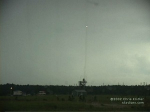
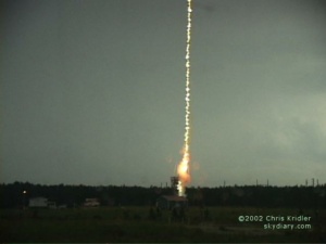
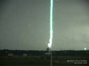
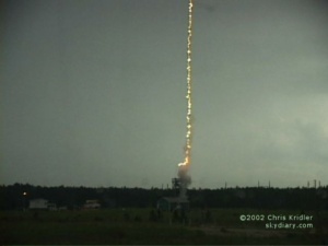
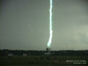
At Camp Blanding, Florida, the University of Florida has a lightning research facility. There, triggered lightning is used in a variety of experiments. Small rockets are launched from tubes at the top of a tower during a storm, building up positive charge as they zoom upward and attract lightning. A trailing copper-Kevlar wire guides lightning to the ground. The wire is vaporized and return strokes resemble natural lightning enough to be used for research.
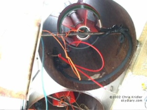
My visit on July 23 on an assignment for my newspaper produced no storms, so lightning couldn’t be triggered. Two days later, a good storm came over the site. The first lightning image is natural lightning, before triggering began.
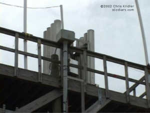
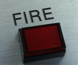
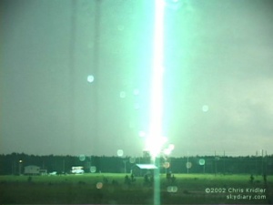
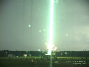
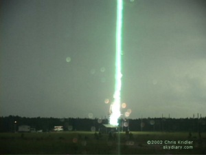
When the negative electric field reaches the right strength, the guys in the launch trailer next to the tower press the fire button.
Here’s a succession of bolts after the rocket is launched. Note that the first bolt goes below the tower as it vaporizes the wire. The rest are return strokes. Images from video.
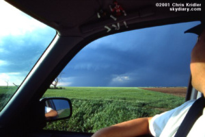
A supercell in northern Kansas on May 8, 2001.
Have I been in the Plains only one day? Yep. Or a day and a half. I left the Melbourne, Florida, area Saturday morning and was chasing in Oklahoma and Texas on Sunday afternoon. Having to traverse such a distance made it hard to get to the action in time … storms fired early, and I missed the tornadoes, which all happened right after the storms initiated. At least they blew in my target area. I was thinking, “I’m not a meteorologist, but I did stay at a Holiday Inn Express last night.”
I checked data at a truck stop in Paris, Texas, then headed north and west. (Thanks to Jay Antle and Steve Sponsler for more info on the way.) At one point I was east of Ardmore, Oklahoma, blasting west to try to catch a warned storm. Its brilliant white anvil cut into the blue sky like a round, hard disk, and its updraft was crisp. It looked powerful and nasty. It was a shock to the system. I hadn’t seen the like in a year! Florida storms simply aren’t that brutish, most of the time.
As I got close to it, it was clear it was not as organized as I had hoped. It was already starting to fall apart. Beneath its black and roiling underbelly, I came across what in a more organized storm might have been a classic wall cloud – the lowered area where you might look for a tornado. But it wasn’t rotating, really, just roiling. Nonetheless, it made me nervous, since it was practically over my head, so I circumnavigated the area. I ended up in the town of Kingston. A bunch of locals – storm spotters and spectators – and some chasers were wandering around too. I’ve never seen so much random motion in the sky, and there were areas where chunks of scud clouds were forming and lifting in the storm. Sometimes such motion is a clue that a tornado could be trying to form, but I just didn’t believe it, given the disorganized state of the storm. Yet I watched with interest, as you might imagine, and jumped when the town’s tornado sirens suddenly launched into their slowly climbing, morose wail. Tornado?! Nope. Just a mess.
I wandered around some more and saw great shafts of sunlight punching through a vast silver cloud deck like the golden fingers of the gods. Very pretty. Not very violent. Darn.
I ran into some old pals from the Cloud 9 Tours group in Kingston again, then eventually ended up over the Red River and among more severe storms in north Texas, where I shot some lightning photos. Then I headed “home,” to Norman, Okla., where I was to meet up with chase partner Dave Lewison.
Today has been relatively relaxed. I spent several hours at the Storm Prediction Center here, checking out the processes, procedures and people for my Florida Today weblog, which is more newspaperish than these bulletins. I also ran errands and bought the Orbital CD recommended by Cheryl Chang and Steve Sponsler, who are back home in Florida – very cool chase music.
Tomorrow, it looks like we’ll head up into north-central Kansas to get into position for iffy possibilities on Wednesday. That could change in the morning. It’s hard to know what’s going to happen, and the weather pattern is really not terribly favorable for severe weather right now. Sigh.
I’m not really in Oklahoma City for storms. I’m here because it’s a good place to end up, the crossroads of the Plains. It’s also a little closer to the storm chaser picnic that’s supposed to happen Sunday in Texas, and I’ll probably end up going there with the folks I’m currently hanging out with: chasers Dave Lewison, George Kourounis and Mark Robinson. George and Mark have come all the way to the Plains from Ontario.
Dave checks out the beautiful supercell in Kansas.
The past few days have been pleasant but not earth-shattering. The tornadic storms have been just about unreachable. On Tuesday, May 8, Dave and I were heading north to Nebraska to get into position for Wednesday when a few wisps of white appeared in the blue sky in northern Kansas. It looked like storm anvils, but we could hardly believe it, given that nothing was supposed to happen at all on Tuesday. We decided to check them out. One of them looked particularly interesting as it developed a base and even a wall cloud in short order as we approached. A severe thunderstorm warning was issued on the storm, which evolved into an elegant, rounded “mothership”-type storm. (See the photo at the top of this post.)
The shape indicated rotation, but the motion seemed subtle. However, it was enough to set off tornado warnings, and though storm spotters reported tornadoes, we never saw anything of the kind despite having a good view of the storm. One police officer told another chaser he was in the area of a reported tornado and didn’t see anything, so we don’t know if the tornadoes were phantoms or not.
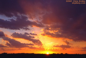
May 8 ended with a nice sunset.
We followed the storm for some time, at one point trying to take a shortcut on a farm road and finding the surface mud as slick as ice. We quickly turned around and fishtailed our way out of there, with soft hail splattering on the windshield as we went. When the storm turned to mush, we resumed our trek north and found another one that also had an intriguing base. It was getting dark, however, and twilight can play tricks on the eyes, making a few wisps of cloud look like an attempt at rotation or something more. We gave up soon enough and headed north to York, Nebraska, for the night.
The next day, May 9, the best area for storms seemed to be western Iowa or southwestern Minnesota. The best wind profile was certainly in Minnesota, and we tried to get as far north as we could, but we simply couldn’t reach the tornadic storm, even though we liked the looks of it. We settled for a pretty, high-based one in southwestern Minnesota that produced a definite swirl for a few minutes, but it was obviously insincere. No tornado. It took forever for the storm to develop the low base that showed it meant business, but despite a period when it was sucking in inflow air, it just couldn’t get its act together. Another storm, with cascading shafts of rain and hail glowing orange with the sunset, collided with that one.
As a storm in southwest Minnesota moved east on May 9, 20001, it was overtaken by this beautiful storm moving northeast, with its gorgeous curtains of hail and rain illuminated by the setting sun.
We’d found George and Mark during the chase, and we all spent the night in Des Moines. We certainly didn’t spot the tornadic potential in eastern Iowa the next day, May 10 – not many did, so few people saw the tornadoes there – so we headed for southwest Iowa. After a while kicking around a truck stop, chatting with other chasers and checking data on the Internet, we liked the looks of northwest Missouri and headed there. Suspense was high, as the cap – the warm layer of air well above the surface – refused to break. We looked at tiny, puffy clouds under a blue sky and waited.
Then – a turkey tower, a skinny (and, frankly, phallic) cloud tower, shot upward. Back to our west, we saw other towers breaking the cap. After some pondering, we decided to go after the storm that had formed near us, as clouds started building into it. We drove to the top of a hill on a tiny side road to take a look. Soon the storm was an explosive convective bomb, growing with hard-edged, crisp, cauliflower blooms, its expansion easily visible to the naked eye. We scrambled east, lurching up and down on precipitously steep hills, with Dave uttering the occasional groan as his stomach flopped while I drove. Yet we all soon stopped our pursuit, because our fantastic bomb had almost no base. It was a dud. And behind us, the line of storms had become severe. A look at radar on Dave’s tiny TV showed that our storm was weak, and though it had begun to suck in some low-level moisture, it was doomed.
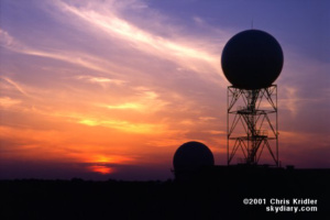
Around May 11, this gorgeous sunset backlit the radar domes at the National Severe Storms Laboratory in Norman, Oklahoma. Image from slide.
We ended up going west and punching into the wind, rain, lightning and hail in the line. We didn’t get monster hail, but we did get quite a hurricane blow when we stopped under a gas-station overhang for shelter in hopes of sampling large hail from a position of safety. The winds were intense and were blowing the rain and small hail almost horizontally. After a Pizza Hut dinner in Maryville, Missouri, it was east into Kansas – a late-night drive to get into position for today. And today, well, not much interesting happened, though even now there are some severe storms in southwest Oklahoma. Mostly we traveled and watched Mark fix his car, an amazing feat. (Trust me. I’m clueless about cars, and I couldn’t believe he was taking bits of engine apart and putting them back together.)
We’re likely to have a quiet few days, so there won’t be much to report. Meanwhile, I had better sleep while I can!
Storm chasing under a high-pressure ridge is the fifth ring of hell. There hasn’t been any actual storm chasing since sometime last week. Right now I’m in Amarillo, Texas, just because a change of scene seemed like a good idea – and because there’s a slim chance something might happen here in a couple of days. But if we want any action tomorrow, we may have to go way the heck up into Kansas. Sigh.
I came out here to the panhandle today from Norman, Oklahoma, with Dave Lewison and George Kourounis (who drives the same kind of car I do, except his is customized beyond imagination). George’s pal Mark had to go home. We’ve been having a pretty good time, at least as good a time a chaser can have under blue skies. It’s been a time to do laundry, get an oil change, etc. Woo-hoo.
This past weekend, I saw the National Memorial in Oklahoma City. It’s a complicated memorial, in some ways, with a reflecting pool framed by giant gates marked 9:01 and 9:03 – the minutes before and after the Murrah Federal Building bombing in 1995; stylized empty chairs representing each of the 168 lives lost; a wall of tiles with children’s drawings commemorating the kids who died; a wall thanking the rescuers; a tree representing the survivors; a chain-link fence decorated with memorabilia; and other architectural details. It’s really too complicated to be contemplative, but it does represent the scope of the event, and for that reason, it’s really interesting to visit. The sense of loss is palpable.
Tonight, we went to The Big Texan. That’s the place where, if you eat a 72-ounce steak (plus the rest of the dinner) in an hour, it’s free! I couldn’t finish even the 7.2-ounce steak, but there was plenty of other stuff to eat, and I ate it. Or tried to. The strawberry shortcake was coated in some kind of scary red goo, however, that made it taste like astronaut food. Plus it was Opry Night, with cloggers and fiddlers and singers doin’ their twangy thang. Also, there were several really big heads of really dead animals on the walls.
So much for entertainment. I’d give almost anything for lightning right now.
We’ve hit another lull in the chase, but at least it’s after some storms! The lull explains why Dave and I are in Carlsbad. We’re going to check out the caverns tomorrow morning – it will be a return visit for me – and might chase storms in the afternoon in western Texas.
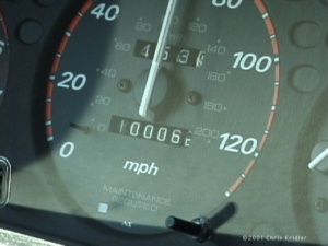 I last wrote on May 15. On May 16, we chased with George in Kansas, but didn’t see much … just some mushy storms and a few lightning bolts. And my car’s odometer turned over 100,000 miles somewhere near Liberal, Kansas.
The next day, storms fired way too early. We stopped in Woodward, Oklahoma, to plug in the laptop and get data early in the afternoon, and when we came out of the truck stop a few minutes later, the sky had exploded in storm anvils. So much for my target of the Texas panhandle! We were suckered by these early-firing storms in central Oklahoma, which went severe and then died as we went after them. It seemed too late to go west, though some interesting storms fired there. We gave up for the day and headed to Norman, Oklahoma, our home away from home. That night, after 3 a.m., we had a great lightning show as a squall line ripped through the Oklahoma City area. Quaking rolls of thunder woke me up, so I opened the curtains on the window in my west-facing room and watched the bolts strike. Then the wind and rain rose like a wave over the roof of the Golden Corral next door, lit up by the parking-lot lights, and a moment later, the squall line hit with huge winds, brilliant flashes and the occasional small hailstone.
Saturday, May 19, was the first day that felt like a real chase, with the possibility of tornadic supercells. The potential for rotating storms was good … and then …
Storms went up too early in the eastern Texas panhandle and western Oklahoma, but there was still potential in and west of Childress. First, Dave, George and I decided to check out the storms going up to the north, since they were so close … and there was a tornado warning on one cell. Yet it had lost its tornadic potential. We quickly realized that the storms were kicking up lots of dust and spewing cold air. In other words, they were outflow-dominant, which means they were croaking. Worse, they were pushing out an outflow boundary, a rush of cold winds that overtook the entire area. All of our southern, warm, juicy, favorable winds were blown into oblivion and became northerly gusts. So as storms went up, they lost almost all potential for rotation.
We ended up in Seymour, Texas, amid massive chaser convergence. I ran into lots of folks I knew, including Arizona chasers John Moore and daughter Beth, Jim Williams, the “Twister Sisters,” Greg Brenneman, National Geographic videographer Dave Linstrom, Keith Brown – who was with the Doppler on Wheels trucks that pulled up at a gas station across the street – and some folks I’d met only recently. After some frolicking and junk food, Dave, George and I decided to drive northeast to get into position for the next day. In short time, north of Archer City, Texas, we got into the small hail of the core of a storm we thought was harmless – and then a tornado warning was issued over the radio! Dave found a radar image on TV, and we used it to try to negotiate the roads to get near the notch in the storm, where there might be circulation. All we saw was rain and hail, though we heard another chaser saw a rotating wall cloud – the area where a tornado MIGHT form – but no tornado.
 After a brief lightning show at our hotel in Denison, Texas, we got a little sleep and got psyched for Sunday, May 20. The Storm Prediction Center’s discussions of the day’s potential included all kinds of signs of doom, and the other data seemed to bear out the potential for tornadoes. We hovered on the Texas-Oklahoma border at a truck stop, checking data on the laptop, then headed into Oklahoma to Atoka in the early afternoon to get nearer to where the action was, in the PDS tornado watch box – or “particularly dangerous situation.” A quick Internet radar check revealed a couple of storms had already gone up north of us, on the boundary. We started heading that way.
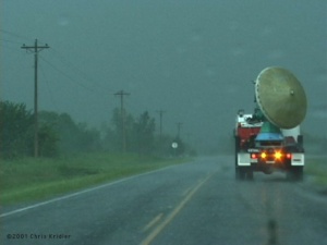 Ahead of us on Route 75 were two Doppler on Wheels trucks. We took this as a good sign, but the circumstances were not good. Chasing in eastern Oklahoma is challenging, to say the least. There are massive hills and lots of trees. It’s very difficult to see storm structure. And rain makes it even worse, and boy, did we get rain – but not yet.
We chose to pursue the western storm. First mistake. The eastern storm, near Dustin, was producing about the only photogenic tornadoes of the day, unknown to us. Our storm had a wall cloud, but it didn’t look that good. We decided we needed to get to the eastern storm.
After several excruciating minutes of driving on Route 9 through blinding rain, whipping winds and hail – and past tree and telephone-poll damage from a previous tornado – we got in the clear, just in time for the eastern storm to weaken. It was being overtaken by the western storm, as radar on the TV made clear. So in true storm chaser tradition, we changed our minds and decided to go in a circle, of sorts.
We dropped south, then slightly west on Route 52 and ended up on an overpass over the turnpike. A circus was unfolding below. Cars were stopped up and down the highway, and a guy was sitting atop the overpass, looking at the tornado-warned storm bearing down on the crowd. “I’m safe,” he told me. “We can hide under this overpass.” I replied: “This overpass is no protection. If a tornado hits while you’re under there, it will kill you.” I advised him to seek better shelter. People were killed during the big 1999 Oklahoma City tornadoes when they hid under overpasses. I decided to be blunt.
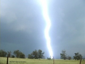
The storm paid no attention to the circus. To our north, the new meso (mesocyclone, or area of rotation) was hanging majestically over the road and was moving east rapidly. We were in trouble, not because we were in danger, but because we had no road options. We couldn’t retrace our steps, because the storm was moving too fast and had overtaken the road. We had to go east on a road that went out of the tiny town of Hanna. And boy, what a road that was! We had to negotiate huge hills and curves on a narrow, bumpy road that was only occasionally paved. Meanwhile, we had to stair-step north to get back to a real road, which meant flirting with the area of rotation while our view of the meso was continually blocked by trees. We were facing a deadline, as well: If we didn’t get off the dirt road before the rain hit, it would instantly turn to “pudding,” as George put it. We’d be stuck.
As the first raindrops fell, a dark, newly paved stretch of road with a bright yellow line opened up before us. I felt like Dorothy, ecstatic upon seeing the Emerald City for the first time. We hit the paved road as the rain and hail slammed us. The hail probably didn’t get much bigger than quarter-size, but it was enough to add some more dimples to my hood. Then we were back on Route 9, heading east, trying to get out of the blinding precipitation.
Another tornado warning was issued for the storm, for an area of rotation north of where we were. Meanwhile, we were hearing warnings on the radio and television for all over eastern Oklahoma. But on the whole, these weren’t big, photogenic tornadoes that could be clearly seen. These were more dangerous – wrapped in rain and nearly invisible. As we headed east, we were keenly aware of which direction the wind was coming from. If the wind suddenly switched from north to south, that would indicate a tornadic circulation to our north.
On the western edge of Stigler, the winds suddenly turned southwest, then south. “OK, here we go!” Dave said.
I was looking immediately to our left, less than a mile north of the road. “That could be a tornado! I think that’s a tornado!” I was saying. I turned my video camera quickly toward the conelike blob that briefly appeared in the rain as I accelerated. I saw a police car that was observing the storm north of the road back suddenly into a car wash. I suspect the officer saw what we saw – whatever it was.
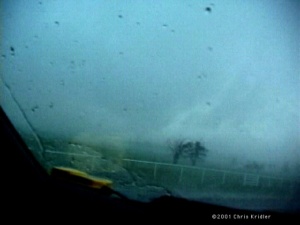 Certainly, we were in a tornadic circulation, if not just south of a tornado, and my adrenaline was high. It’s the first time I ever felt truly in danger from a storm. In town, the sirens were screaming. Some guy was poking along ahead of me as if he was out shopping for flowers. I flashed my lights and he moved over. At a red light, I stopped, made sure no cars were coming, then went through with my blinkers on. Dave was aghast. I said, “It’s a #&%*$ tornado, Dave, I’m running the red light!” As we pushed through town, rain curtains ahead of us were clearly rushing from right to left, wrapping around the area of rotation. We were in the “bear’s cage,” no doubt about it.
Finally, we broke clear to the east and had the first decent view all day of the beast. A huge, greenish core was filling in the meso. Lots of cloud motion was on the curved front edge, and a shelf-like cloud feature could be seen to the north of the rotation. Hot lightning was striking everywhere. At one brief stop to videotape it – all of our stops were brief, because it was moving so rapidly – a bright bolt hit probably a quarter mile from the car. The bolt itself didn’t surprise me, but the nearly simultaneous sky-ripping crack and bang of thunder almost made me drop the camera. I was breathing as fast as a rabbit for several seconds afterward. Scary stuff, even though I was in the car, which provides some protection. Lightning can kill you. That didn’t occur to the guy standing nearby, in his front yard, watching the storm come in. “You might want to seek shelter!” I shouted out the window as we drove off his little farm road and back onto Route 9, headed east.
The HP or high-precipitation storm soon became a less appealing, less chaseable object as darkness began to fall. We headed south to another storm that had a pronounced hook on radar. Dave’s radar updates from the TV had saved us all day – or perhaps lured us into danger – and because we knew where the dangerous area of rotation area was on the new storm, we stopped in Wister, Oklahoma, to let it pass. That’s Wister, “as in twister,” as Dave said.
When we finally gave up for the night, we grabbed some food at a nearby McDonald’s and then headed west toward McAlester, where we’d made hotel reservations. We were tired of chasing – but still had to drive through multiple severe storms to get there! I was fried. I’d been driving all day. And when the lightning is strobing constantly in the darkness, the human eye simply can’t adjust quickly enough. So my eyes hurt, my bones hurt, and anyway, enough whining … we finally got there and found that three other teams of chasers had checked in before us. Among them were Bill Hark and Kinney Adams. We said hi and enjoyed a lightning crawler show before crashing for the night.
It’s been a calm couple of days of recovery. Last night, a bunch of chasers got together in Norman to watch “Shrek” (very entertaining!) and grab dinner. Among them were Keith, Bill, Dave Fogel, Jason Persoff, Shane Adams and some other folks. Back at the hotel, Bill, Dave, George and I had some cake (with a tornado on it, of course) to mark George’s 31st birthday. He said he made a wish for all of us when he blew out the candles – and we all know what that means. Though I’m too superstitious to mention the “T” word.
That’s it for storm action, for now. Tomorrow, caves and storms, I hope. This has been one of the driest storm-chasing seasons I’ve experienced. But I’m trying to look at the bright side (it’s too bright, actually – I’m getting sunburned). And at least I’ve had one memorable day.
Today, I start my drive back to Florida, after a great final week of storms. Meanwhile, Dave is driving us to Norman, Oklahoma, where he’ll remain to chase with the Cloud 9 Tours folks for a couple of weeks. So I have a few minutes to recount the agony (hail trashed my car) and the ecstasy (a beautiful tornado in Colorado).
The last time I wrote, we were about to see the caves at Carlsbad, New Mexico. We went through the main caverns on May 24, which was a good hike and more strenuous than I remembered. It’s about four miles, the first half of which is a steep descent into the cave on a switchback trail. My leg muscles were trembling by the time we hit the lower chambers. The caves are awesome, a kind of underground cathedral hung with chandeliers of glistening mineral formations and bristling with spikes and curtains of rock. Unfortunately, we didn’t stay to see the evening bat flight (another reason to go back), as we booked east toward the place where storms would fire. Fire they did, far south in Texas, and we couldn’t get on the south (i.e. picturesque) side of them in time. Still, we were treated to a beautiful sunset before our evening in San Angelo.
The town was rife with giant black beetles, which are apparently swarming all over Texas this year, along with a profusion of irritating moths. In some places we’ve visited, there are so many beetles they’re crawling all over each other and the walls, cannibalizing each other, carrying around the heads of their dead buddies, and giving off a sickly sweet stench when smushed. In short, yuck.
The next day was a pure bust near Junction, Texas. Dave and I met up with Bill Hark and sat around for hours, waiting in vain for nonexistent storms. So did other chasers all over southern Texas, as we found out when we met a bunch for dinner in Abilene.
May 26 was much more promising, a good dryline chase day in the Texas panhandle. When the first two storms went up, Dave, Bill and I headed toward a storm near Matador, Texas, and, inevitably, ran into the Cloud 9 Tours group again as the LP (low-precipitation) storm evolved. It looked good for a while, but soon storms were mushrooming all over the panhandle, and the result was a giant cluster of precipitation and chasers. We followed some nice stuff, then finally decided to drive through some rain and hail to see what was on the other side.
Let me point out that I never drive through hail if I think it’s big. This hail was not particularly big. I say this now lest you think me an idiot when I tell you about the hail from hell, which we went through a few days later.
So … we got through the hail while following a mobile radar from the University of Massachusetts, as light filtered through the curtains of precipitation and hot lightning hit all around. The sight on the other side was spectacular. In the clear air, we looked back toward the east to see the hail falling out of the storm in a brilliant white curtain, with a hailbow – a rainbow produced by hail! I could barely stand up to videotape it as cold outflow winds blasted toward us. We attempted to circumnavigate the core and get back east into better position, but the storms had turned into a squall line, and instead of chasing them, we enjoyed the mammatus show. Fields of the pouchy clouds were hanging from the anvils of the storms, side-lit orange by the setting sun.
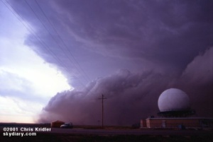 May 27 was a blast, or, you might say, a sandblast. Dave, Bill and I met up with Steve Sponsler and headed up into Kansas. We had hopes for supercells, but most storms were going up early and beginning to merge in a messy line. At a truck stop in Sublette, we looked at radar images and weighed our options as the sky outside became more and more ominous. By the time we headed north, it was too late to get individual cells … the whole mess had merged into a great line, a dramatic shelf cloud rolling toward us, kicking up brown dirt underneath it as it went. We stopped by a radar dome and got video and stills as it approached. Then the first dust hit. It was a haboob, a Dust Bowl storm, a roaring animal.
We leapt into our cars and headed south again to the truck stop to take shelter under the roof, in case there was hail to contend with. Instead, we were blasted with winds that some people measured at 80 mph or higher. The dust and gravel from the fields and parking lot pelted the car as the winds knocked over trash barrels and sent bits of branches zooming by. We saw a bird flying backward – it couldn’t compete against the inexorable winds. After several minutes of sandblasting, it was pretty much over, with no hail, just some rain. We looked at some other pretty convection, then went our separate ways.
On the way to Woodward, Oklahoma, where we had hotel reservations, Dave and I saw a lot of damage from the straight-line winds – trees knocked down, a blown-over tractor-trailer and power outages. We ran into Bill at the gas station in Woodward, had some pizza and crashed for another night.
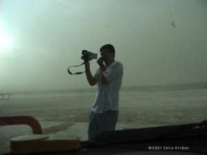
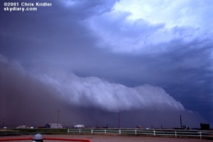
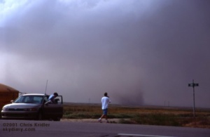
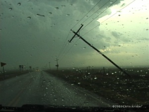
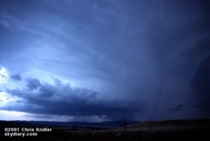 Upslope storms – the kind that form on the higher elevations near the mountains – seemed the best bet for May 28. The phones were out in the hotel, which was a very plush Super 8, I might add, so we got the basics on the day’s outlook from Jay Antle and began meandering west. We met up with Ed Roberts from Kansas City and some other chasers in Guymon, Oklahoma, who kindly shared some data files they’d pulled, and we headed farther west. In Dalhart, Texas, a nice woman at the Holiday Inn Express let us plug in for a few minutes to get more information, and we headed for Clayton, New Mexico. If you’re counting, that’s three states already.
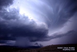
A field of low clouds was obscuring our view, so Dave called Philip Flory, a teenager who knows way more about weather than I do. He’s been doing some “nowcasting” – recounting current conditions, storm positions and so on – for chasers this year. He told us of a nice storm going up in Colorado, so we headed that way. And boy, am I glad we did.
We were treated to a succession of nicely structured, LP storms coming off the mountains. The first couple died, however, after forming in the same place. We decided to get closer to their point of origin and, north of Trinidad, Colorado, ran into Scott Blair and Jason Politte from Arkansas.
A spurt of hail later, another, beautiful “mothership” storm formed over the mountains, visibly rotating and producing a wall cloud and what looked like a funnel. We followed it northeast a bit, and though it looked as if it wanted to produce a tornado, it followed in the steps of its brethren and fell apart as the sun set.
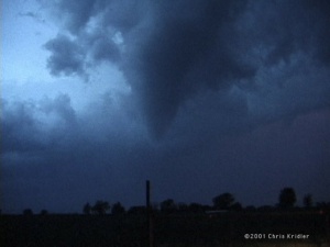
Yet another storm had formed just behind it, and this new meso – mesocyclone, or area of rotation – was classic. About a mile from us, it exhibited all the signs of a forming tornado. A rear-flank downdraft cut in, creating a visible clear area as the circulation tightened into a funnel.
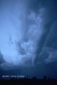
As it got closer, the funnel elongated, clearly spinning, stretching nearly to the ground and becoming pointy. This was later confirmed as a tornado and did a little damage – there was certainly circulation on the ground, though we couldn’t see debris there.
As it danced its slow ballet in the glooming dusk for about 10 minutes, the funnel elongated and then evolved into the wispy rope stage, a slim snake curling in the air and then dissipating. What a show – and we were right next to it!
The meso was still strong, and we were tempted to follow it. We did, for a bit, but chasing a tornadic storm in the dark in the rain is not safe.
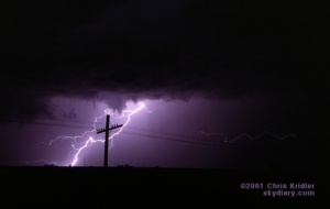
We stayed to the southwest of the meso for a bit, watching it being illuminated by lightning, then gave up for the night. After dinner with some other chasers who’d had a great view of the tornado from a bit farther away, we headed back to Clayton for the night.
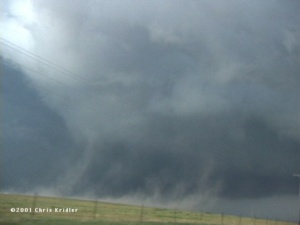
May 29 promised serious tornado potential that was only partly fulfilled as several discrete storms formed along the Texas dryline in a strongly sheared wind environment. Dave and I monitored radar at a data stop in Vega, Texas, then went after almost the first storm that formed, south of I-40.
It took a while to get organized, but several times, the rear-flank downdraft cut in and tried to spin up a tornado. Soon, the thing was a giant rotating beast, and at one point, a massive RFD was kicking up so much dust, we were sure it was going to do it. Meanwhile, we were navigating around more chasers than I’d ever seen on a storm – dozens of cars on a tiny farm road, tourists, researchers, mobile radars, you name it. It looked like rush hour.
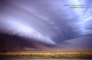
We heard a tornado-on-the-ground report from a storm farther north (the massive White Deer tornado), but we didn’t want to leave our supercell, and as we got ahead of it I was glad. The thing had a structure unlike any I’d ever seen. First it seemed like a big flying saucer, sucking in red earth near Quitaque. Later, it was a wedding cake, visibly rotating.
Then, at sunset, it was almost like a barrel. We watched it spinning near Childress, where the tornado sirens were going off. Though it never produced a big tornado (as the storm near White Deer did), it was a gorgeous, dramatic monster that spit out a lot of small spinups, and I’m thrilled that I saw it.
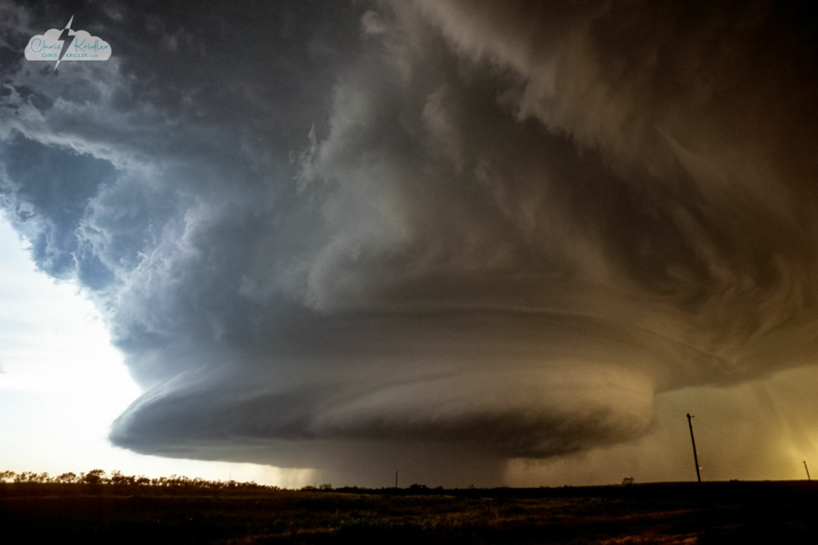
The supercell looked like a UFO.
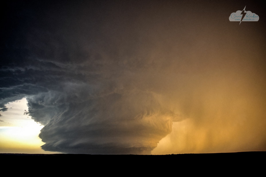
Incredible structure.
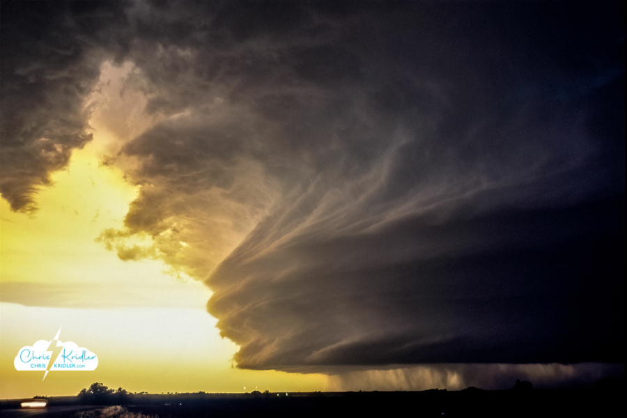
The magnificent layer cake supercell near Childress, Texas, on May 29, 2001.
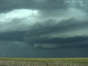
As you can see, we haven’t had much of a break, until we had to take one to fix the car. Which leads me to May 30. Though there was a better risk of severe storms in southeastern Oklahoma, the wind profiles weren’t good for supercells, so we decided to play the upslope in New Mexico. We joined up with Scott and Jason again, and as we approached the New Mexico border, we saw a full-fledged supercell already sprouting by 1:30 p.m.! We booked to it as quickly as we could and up a steep mountain road to the town of Mosquero, New Mexico. The storm slowly began to organize, rotating cyclonically (counter-clockwise) at the mid-levels and, at least to the eye, anti-cyclonically at the lower levels. As it, and we, came off the mountain, the thing was clearly a beast, with a large white-and-green hail core. It also looked more linear. Convinced it was gusting out, we headed east, then noticed that it had begun to reorganize. It was another beautiful rotating storm, with a wall cloud and what might have been a funnel under it!
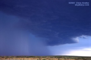
Keeping up with it on the terrible New Mexico road network proved nearly impossible. It was moving southeast. Our strategy was to get on the interstate and get ahead of it, going east. We quickly fueled up, then headed east.
The weather radio said the storm was moving slowly. It wasn’t. We thought we could easily get past the storm – until it was on top of us. This supercell was quickly cycling through mesos – old ones were being rapidly wrapped up by curtains of hail and rain, and the storm had gone through half a dozen such cycles before it hit the interstate.
Unfortunately, we met it there, at mile 6 in Texas on I-40, east of Glenrio. Hail wrapped behind us before we realized how fast it was going. Our speed couldn’t get us into the clear, which we could see just ahead. In the span of a few seconds, Scott was on the radio, saying he saw dime size hail – bigger than dime size – baseballs hitting the road!
“Did he say baseballs?” I said. It was too late. BAM! One of the first big stones took my windshield, putting big circular cracks in it. We couldn’t outrun the storm without intensifying the force of the collisions. We had to pull off as the barrage began in earnest. The size of the stones got a bit smaller, but these were high-plains tennis balls and golf balls, rock-hard ice formed by cold air aloft.
I was scared, but I had video rolling. I held the road atlas up to the driver’s side window to protect myself in case it shattered and felt it wildly vibrating, radiating the cold caused by the hail that was slamming it. The stones were blowing almost horizontally, probably at 70 miles per hour. The car was rocking. As the onslaught lightened a bit, I tried to move my car back a bit and straighten it out – I’d angled it so the hail wouldn’t be hitting the side windows dead-on. We were stuck, but a few attempts forward and back, and we were released from the mud.
The hail attack, which started about 6:40 p.m. central, continued for probably 10 minutes. When it was over, all of us had lost lights – the entire column of taillights on one side of my car was completely bashed out. I’d lost the only window, the front. Jason and Scott had serious damage to their antenna racks, mirrors and other parts of their cars. In fact, Jason’s had quit and couldn’t be restarted. He realized later that the fuel switch had automatically turned off because the car thought it had been in an accident.
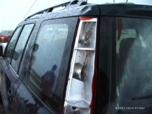
And then there were the dents. ARE the dents. These can’t be fixed. The hood, roof and entire left side of my car look like rippling water. Plus there are a few serious craters, especially on the back left corner. The hail even chipped some paint off. So the next two days, I was making phone calls and arrangements and repairs. The windshield’s been replaced, the chips have been touched up, and thanks to Dave’s engineering instinct, the taillight piece was replaced in about five minutes (after I spent a lot for the part, of course).
We found out we were almost lucky … when Scott and Jason went back to get Jason’s car, they saw a tractor-trailer a few miles west of where we were with lots of bashes and multiple smashed windows. Softball hail was reported west of us. The damage could have been much more serious – to both our cars and ourselves.
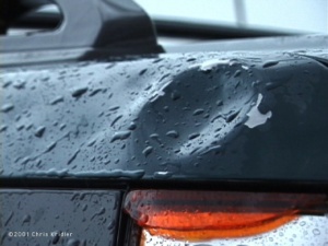
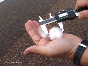
So … Dave and I chased yesterday, June 1. We got on more spinning cells in Kansas, beautiful things that had such huge RFDs, the downdrafts practically ripped them apart. As we were watching one nice storm with a decent meso, the Cloud 9 Tours folks pulled up, and immediately started filming – my car. Yes, it’s that wild looking.
We saw some funnel clouds out of the storms before they simply evaporated from the bottom up, still spinning, as they apparently ran out of moisture. Great photo ops, and a nice way to end the chase. We met up with Jason and Scott, as well as Matt Crowther, Betsy Abrams, Jay Antle, Mike Umscheid and their crew at Casey’s Cowtown Steakhouse in Dodge City.
Now I face the horror of driving across the country. I had a dream about teleportation last night. It would be great to teleport to storms … or teleport home. But it doesn’t work that way.
Here’s just one of the lightning shots I got in the summer of 2001 in eastern Florida, near Cocoa.
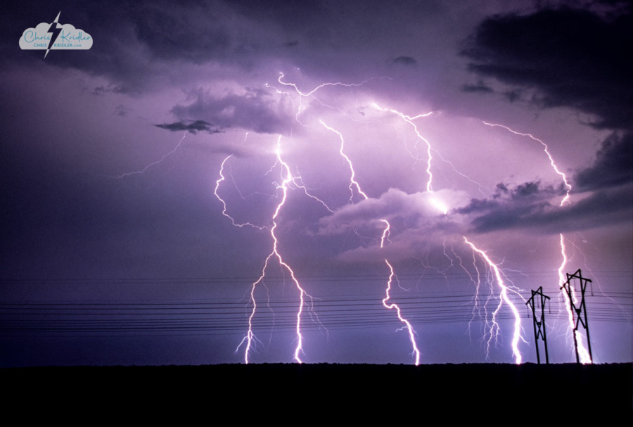
Lightning near Cocoa, Florida, on June 16, 2001.
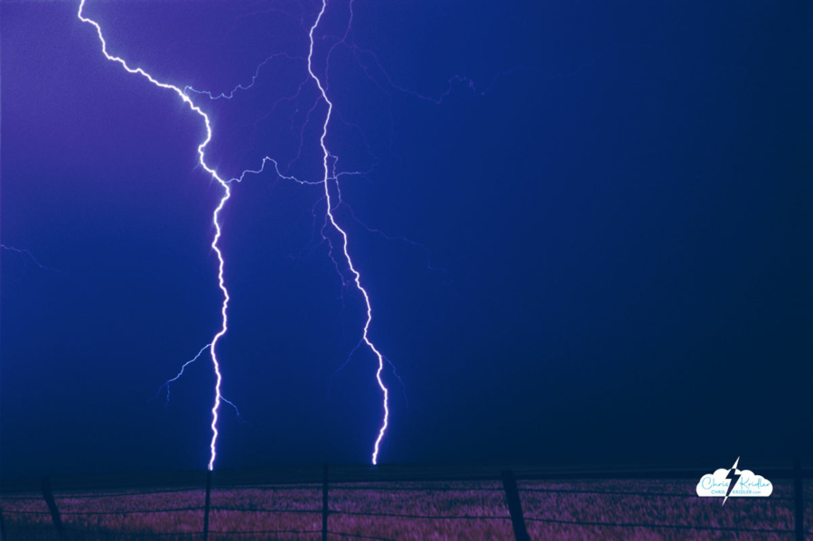
Bolts May 25, 2000, near Claude, Texas.
I have extensive archives from my early storm chasing years. I chronicled almost every day on the road, even bust days, at the old SkyDiary site, with lots of photos. In the interest of collecting everything in one place, I’m moving the highlights of the older chases – or quirky moments worth remembering – over to ChrisKridler.com. With that in mind, this post collects some of the accounts from 2000 and select photos to accompany them. They are slightly edited. Dates reflect when each bulletin was written.
JUNCTION CITY, Kansas … May 10, 2000
Chasing storms is a bit like playing chess with the sky when all you know is checkers. The sky, unpredictable and complicated, always wins.
There hasn’t been much to chase so far. I set out Saturday from Florida for parts west — a 15-hour drive that put me in Monroe, Louisiana, for the night. The highlight was entering Mobile, Alabama, over an expanse of water, on a long, curving road at twilight. The sky was deepening into dark, and the highway was punctuated with street lamps, strung out before me like beads on a necklace. The low point was a psycho trucker who was harassing me by rushing up to get on my bumper, passing me, slowing to a crawl, waiting until I passed him, and then beeping at me. This happened several times until I got off the highway and took a little nap at a rest stop. I needed it anyway, as sleep-deprived as I was.
The second day’s drive … only eight hours … got me to Norman, Oklahoma. The next morning, after seeing some of the old faces from Cloud 9 Tours, Dave Lewison and I set out. We drove around in circles for hours and hours, trying to play a warm, moist area ahead of the cold front in central Oklahoma. Instead, a few storms broke out behind the front near nightfall, but considering the distance we had traveled and their relative wimpiness, they didn’t seem worth lingering over. We saw a few flashes of lightning in the storms, north of Oklahoma City, as we set off for Lubbock, Texas, where I had to do some interviews for my paper the next morning. We arrived just before 4 a.m. More sleep deprivation!
At Texas Tech, we got to see the sensor-studded building that researchers rotate to face into the wind. We talked to some knowledgeable folks about the latest in storm shelters. We also saw a few dust devils in a field outside town. Dave “punched the core” of one — running into it, that is. He was brushing away dust all day afterward. This is what storm chasers do for off-day excitement.
Today was a gruelling drive in anticipation of marginal storms that never showed up. We realized that would be the case by mid-afternoon but wanted to get into position for tomorrow. The problem is, tomorrow’s chances are way the heck east — Iowa, Minnesota, even Wisconsin — and I don’t know if we can make it from here, near Manhattan, Kansas. So we’ll have to decide after looking at data in the morning.
At least it’s good to be roaming the Plains again. We’ve been through one small town after another, dusty monuments to perserverance that fall apart a little more every year as the wind howls across the flat, desolate and strangely lovely land. There was the historic windmill park in southwest Oklahoma… the Kinsley, Kansas, sign marking the “Midway U.S.A.” point between New York and San Francisco … a sign for “Shotgun Dave’s Viking Barbecue” … a little Kansas carnival … the faux dinosaur that sits atop a hill in the northern Texas panhandle … long trains that snake through the hills and over the flats … a water tower in central Oklahoma that looks like a peach (but not like the famous butt-shaped peach tower of Gaffney, S.C. — thank goodness).
We shot some pictures today of a burnt orange sun setting behind a pumping oil well. It was a cliche, but a beautiful cliche.
Tomorrow … who knows?
SALINA, Kansas… May 15, 2000
We’ve been driving so much, I’ve hardly had time to write a thing. But here we are, in Salina, Kansas, on the eve of another chase day.
 Last Thursday, Dave and I targeted northeast Iowa. Low pressure was moving into the area, which would cause the surface winds to come from the south or southeast, while upper-level winds were streaming in from the west. The result: shear in the atmosphere, meaning if a storm went up — and it was likely where the warm and cold fronts met — it would probably rotate.
Dave and I found ourselves in an area with a 74-degree dewpoint and promising cumulus clouds that were starting to bubble up and bump against the warm layer of air known as the cap. One area seemed particularly promising, as the towers became hard and aggressive there before collapsing. They got bigger as time went on. It seemed that any moment one might burst through. We sat on a dusty farm road west of Grundy Center and waited, with phone calls to Steve Sponsler and Cheryl Chang back in Florida confirming that we were in the right place. About this time, California chaser Mark Aubin met up with us.
Then the beast exploded.
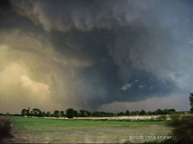
This is the storm that would produce a damaging tornado in Dunkerton. The truth is, it was a tornado machine. As we pursued the rapidly expanding cell, heading north to catch up with it, we saw it developing a succession of rotating wall clouds and kicking up dust. Unfortunately, we missed the first two powerful tornadoes as we found ourselves stuck in the town of Waterloo. Navigating around it cost us valuable time and position. We had no idea a couple of giant tornadoes (as seen on The Weather Channel) were chewing through an area well north of us. The chasers who saw those tornadoes punched into the storm from the north.
Our efforts were not in vain, however. We navigated a series of gravel farm roads to keep up with the beast, which had several mesos — mesocyclones or areas of rotation — at once. While we watched the storm, Dave watched it on his tiny TV too — a crazy man in a helicopter was flying around the supercell, filming it for a local television station. The first obvious tornado that we saw was backlit by lightning and produced a bowl of dust under the meso. It also produced a fast, white satellite funnel that orbited around the main funnel — one of the most amazing things I’ve seen. It was a multiple-vortex monster. The storm produced another tornado near the multiple-vortex funnel, then another one in a field just to the east … and very near us.
It was getting dark at this time. We thought we’d attack the western portion of the storm, where it looked promising on radar (as seen on TV!), then changed our minds and headed east to keep up with the leading edge. I got some eerie video near Manchester of some suspicious-looking clouds looming over the land, seen in brief moments, lit by lightning flashes, as tornado sirens went off. I am pretty sure they were “scud” clouds, raggedy clouds on the leading edge of the storm, though they had a funnel shape. We heard damage reports from Dunkerton and realized we’d missed some of the tornadoes, but we’d seen a storm of tremendous and humbling power.
Friday was hardly worth the drive into Illinois. Though we were in the midst of multiple warnings, we could see almost nothing because of the haze, mushy clouds and precipitation. And struggling against the heavy traffic in populated areas didn’t help either. It became a war of attrition. We were in Mattoon when the sirens went off, with a screaming south wind blowing horizontal rain at us. That suggested there might be a meso nearby, but we couldn’t see crap! We got some marble-sized hail and saw some hot lightning out of the storms, then headed back west. Frankly, I was relieved to cross the Mississippi again and spend the night in Missouri. The next day, we were back in Oklahoma.
The annual storm chaser party was Sunday in Texas, at Storm Track editor Tim Marshall’s palatial home, where we saw lots of chasers and lots of video. It was a true geekfest, and there were very few women present. I interviewed a few chasers for a Florida Today story about gear and gadgets — boy, do I feel ill-equipped now.
Now, we await what a huge trough will bring to the Plains in the next couple of days. I expect we’ll head to western Nebraska tomorrow. The skies could get really violent by Wednesday. Or not.
It’s all about the moment. An orange sunset. A green wheat field. A stroke of white lightning slicing open a midnight sky.
I have no idea what’s next. I like it that way.
FORT WORTH, Texas … I-35, en route to Abilene … May 19, 2000
There’s nothing like a really good day followed by a really bad day. The really bad day makes you forget how good the good day was. Too bad it didn’t work the other way.
No doubt many of you have seen the footage of the big tornado in Nebraska on Wednesday. And no, I wasn’t there. Dave and I teamed up with Jay Antle in Ogallala, Nebraska, and checked data on the Web that morning (May 17). We targeted an area southeast of there and ran into several other chasers at a truck stop in Elm Creek. As storms went up north/northeast of the low, we decided to play the area just southeast of the first storm, where we thought more storms would fire, in an atmosphere more conducive to tornadic supercells. But this low had other things in mind. The northernmost storm — not the southern one, as often occurs — was the one that produced the tornadoes. We still feel sick after missing it. We played the storm south of it, but it just didn’t do it. As other storms went up, none of them survived the strange dynamics.
The only comforting thing is that we ran into a lot of other chasers who also found themselves farther south. However, one, legendary chaser David Hoadley, went north in time to catch the big tornado, as we found out later. We could have caught it if we’d shot north. For us, it was a “wet bust” — we saw storms but missed the storm of the day.
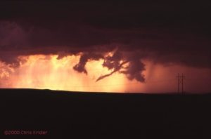 Going backwards in time to May 16 — the day before — we played what seemed iffy chances for supercells in western Nebraska. We thought the action would be in extreme western Nebraska or even eastern Wyoming, especially after checking data and running into chasers Keith Brown and David Fogel (again in Ogallala). As we zoomed west, it became clear that this was going to be a major chaser convergence. Translated: A circus of idiot drivers. Now, obviously, I don’t think all chasers are irresponsible, but there are definitely chasers who are giving the rest of us a bad name. They are also becoming incredibly ostentatious, with loads of silly equipment on their roofs, including (in my opinion) useless marine radar units. What, are they going boating in their Ford Expeditions?
We saw a big anvil from a massive storm as we neared the state border, so we took the plunge into Wyoming (a new state for me). Not much good structure was evident, but as soon as we got close enough, we could see what appeared to be two wall clouds hanging from its base. This storm had potential after all.
We kept driving closer to it, with our view hampered by lovely foothills — nearly mountains — as the storm produced a big, cone-shaped funnel. By all accounts, it didn’t touch the ground, though we had a pleasing optical illusion with the bottom of the cone obscured by a peak. It sure looked like a tornado!
As we passed several chasers parked by the side of the road and got through Guernsey, we proceeded uphill again to a beautiful vantage point east of the area of rotation. We were nearly alone (for a while) at this lofty spot. The storm produced a finger-shaped funnel that became a wispy rope, appearing to touch down only at the last moment. It seemed that, yes, we saw a tornado, the most ephemeral of tornadoes, backlit in orange as it dissipated in a sinuous tendril of smoke-gray vapor.
The tornadic show was over, but the light show was not. What followed was an incredible sunset of blues, greens, purples and oranges, muted by curtains of rain, waves of dust and roiling clouds, which gave the sky the feel of a rich, abstract watercolor. Paralleling the road were more trains than I’d ever seen, their headlights bright as they crept alongside the roadway, as if trying to find their way out of a mist.
After dark, we ran into the Cloud 9 Tours group at a Pizza Hut, where we could see an amazing lightning display and gusting clouds of dust outside. The group was a bit dejected at its bad view of the teeny tornado, but they would all feel a lot better the next day — they saw the big Nebraska storm.
Right now, as I write this, we’re traveling under the messy rain and corpulent gray clouds of the cold front hanging over north Texas. (Dave is driving, of course!) We saw some great lightning in north Texas last night, but it wasn’t close enough — we tried to get closer, but in our fatigued state, we just couldn’t drive any farther after leaving Hastings, Nebraska, yesterday morning. We have slim hopes of storms in west Texas on Saturday. Then Dave joins Cloud 9 Sunday, while I go my own way.
NORMAN, Oklahoma … May 22, 2000, 1:44 a.m. central time
I’ll make this a short bulletin, since there’s not much to report. Chaser angst has set in big-time.
Sunny days are dreadful when all you want is storms. But it’s amazing how weak dynamics will produce storms anyway. The magical Texas panhandle has kicked off storms for two nights running. Saturday night Dave and I caught some fabulous lightning in the panhandle and western Oklahoma; I have yet to see if any of it showed up on film, as I haven’t had my slides developed yet. I’m not terribly hopeful, as I’m still learning my way around both lightning photography and my new camera. But the experience was satisfying.
Tonight, the storms came to us, in Oklahoma City, though the line was a brief and unimpressive distraction.
I expect to set out for Kansas tomorrow.
ALTUS, Oklahoma … Friday, May 26, 2000
Many chases and, before you ask, no new tornadoes.
I know, it’s not really about the tornadoes. But more and more, I get irritated if there are tornadoes and I don’t see them.
Monday, I was going to head to Goodland, Kansas, to start work on an article about the latest severe-weather research project. Instead, kicking around on a hot afternoon in the Guest Inn parking lot after a local photo lab in Norman, Oklahoma, scratched — nay, scraped! — some of my precious slides during developing — an impromptu chase developed. A look at data revealed a bullseye of potential developing over northeast Oklahoma. The caravan: George Kourounis, with Dave as a passenger (Cloud 9 Tours wasn’t chasing that day, so Dave, who had joined the tours, rode with George); Richard Bedard, author of “In the Shadow of the Tornado” (nice book!); and myself.
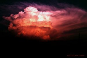 We saw the storm from when it was a pup, a little towering cumulus. It exploded and soon became a big bad dog — isolated. Huge. Multiple overshooting tops. But it was SCREAMING southeast, way ahead of us. It zoomed into Arkansas (Richard left us in mid-chase because of the hopelessness of the pursuit), and we had to listen to hail reports and spotter-reported tornado warning(s) as we tried to pursue it. We ended up in Arkansas, just east of Fort Smith, with a photogenic bomb that formed on its backside — very pretty, though it croaked at sunset. We met David O. Stillings, the Lightning Stalker (that’s just how he introduces himself, too, at rat-a-tat speed) and Jason Persoff, both Florida chasers traveling with a Pioneer Productions TV crew, as well as a couple of Arkansas chasers — Jason Politte and Scott Blair. We’re all part of a strange, little mobile community that keeps meeting on the grassy banks of farm roads in the middle of nowhere.
The distant chase meant, after yet another meal at Pizza Hut, that I had to make strides toward Goodland, on the western edge of Kansas. To make a long story shorter, after a stay in Salina, Kansas, that night (or morning, actually), I got to Goodland the next afternoon and did some of my reporting Wednesday before heading south to try to catch some potential storms in Oklahoma and Texas. While checking data at a truck stop in Cimarron, Kansas, I noticed a couple of puffs of white on the satellite image in the most promising area. But the time I’d gone outside and filled up the tank, the puffs of white were aggressively building storms, in sight to my south, on the border of the Oklahoma and Texas panhandles. I ended up punching the core of one, but it was just a huge HP (high-precipitation) mess. Got a fantastic rainbow and lovely sunset near a windmill on the west side, however, as well as some pretty lightning while I headed for Woodward, Oklahoma, where I spent the night.
Thursday was a romp through the Oklahoma and Texas panhandles — I was supposed to meet Cheryl Chang and entourage in Guymon, Oklahoma, but when I got there and called her she was a zillion miles away in Amarillo. Hmmm. I ended up on my own, getting into a mean storm in eastern New Mexico; I found the storm’s base at the heart of its curtains of rain just as the storm began to collapse. My car was caught in the gust-out as dirt and vegetation blew across the road in front of me at what I’m guessing was, at times, 50 mph wind. As the car is buffeted while I speed south, you can hear me babbling on my videotape, “Uh oh. I’m in trouble. I might have to stop and turn my car into the wind here …” I was both dreading and hoping that it would produce a tornado right behind me before it completely blew itself apart.
Trapped in the road network from hell, I made it out of the maze of dirt roads (thank you, GPS!) and back into the gorgeous and desolate hills of the western Texas panhandle, following and penetrating the storms again. I got in the clear and saw a decent base on the storm I’d been through, but few roads and the need for fuel prompted a detour in Amarillo.
I heard the tornado warning too late to get there.
Twenty minutes can make all the difference when it’s nearly 9 p.m. Daylight is almost gone. And the spotter-reported tornado, southwest of Amarillo near Dawn, Texas, on a completely different storm, was over by the time I intercepted the storm. By then, the sky was pitch-black anyway, notwithstanding the strobes of lightning.
The storms, however, were not over. Amarillo and surrounding towns were awash in the deluge — there was street flooding everywhere — and Canyon and a few areas east of the city were pounded with softball-size hail. I saw the most amazing lightning show of my life near Claude. It looked as if the hard white bolts were hammering the ground, they were so intense.
Then it was north to Spearman, Texas, to meet Cheryl and her gang at the NursaNickel Motel (really). On the way, I speedboated my way through street flooding in Panhandle — where the bank had its sprinklers running. Duh!
Today was the ultimate in frustration. I don’t claim to be the best forecaster in the world, but I was thinking we should start in an area near Lawton, Oklahoma. We might have caught a long-lived tornadic storm reported later in that region — but we didn’t go that way.
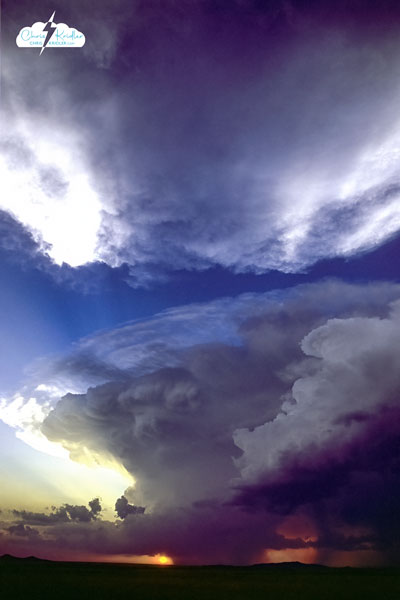
Supercell at Altus, Oklahoma, May 26, 2000.
That’s not to say today was without excitement. The caravan, which included Martin Lisius, Bill Reid and Brian and Nancy Morganti, criss-crossed the Red River, Texas to Oklahoma, back and forth, trying to get into the best position for the show in an atmosphere ripe for severe storms. In a stew of lowering pressure, frontal boundary, dryline convergence and very high dewpoints, towers went up everywhere in the region; some became storms and fizzled, some went crazy. We gave up on one storm to chase another, only to be lured by another that was probably a split from the first storm (which later produced a tornado, weather radio reported). The split — a left turner, we think — behaved in a bizarre manner. Its lowerings suggested a tornado was imminent, but as it sped north, it was showering us with precipitation, though we were east of it. We didn’t realize just how fast it was going as we were blinded by the rain. As it made its escape, it THWACKED us with buckets of hail! I haven’t inspected my car for dents yet, but let’s just say I’m grateful it still has all its windows. I only saw one baseball, but most of what hit the car was golf-ball size and smaller. Big enough!
From there it turned into agony as we heard unreachable tornado warnings. We ended the day looking at a gorgeous, small, almost stationary cell near Altus that had apparently formed behind the tornadic storm well to its north. Its scalloped anvil glowed orange as it formed a bell-shaped updraft base — the shape was suggestive of rotation, but it simply lacked the power to complete the act. It was a lovely confection but a less than satisfying consolation prize.
So, more exhaustion, and another chase day tomorrow. My expectations are lower for tomorrow, so my disappointment should be lessened too.
SIDNEY, Nebraska … May 31, 2000
The day after my last bulletin … Saturday, May 27 … our group was heading south of Altus, Oklahoma, to play a promising area south of Wichita Falls, Texas. It was early afternoon, when you don’t expect severe storms yet, but towers were going up already. We were shocked to hear the tornado warning for a storm near Archer City, Texas, around 1:30 p.m.! We missed two slender, landspout-type tornadoes before we got to the storm, but managed to get south of the cell in time to see a beautiful front-lit, long, white funnel extend from its flank — it lasted for a few minutes, and its rotation was obvious. (I do not believe it was a tornado, as some chasers have said, as we never saw it touch the ground, but it was very persistent.) It was about 2:30 p.m. To get ahead of the storm, we passed dangerously close to the swirling clouds, looking around constantly for signs of trouble as we drove under the edge of the storm, flirting with the hail core. A pickup truck with a bunch of happy, clueless people in the back were heading right into the core. Cheryl rolled down the window and yelled at them to turn around.
A big wall cloud looked like it was getting its act together, and then the storm went linear, forming a shelf cloud and losing its tornadic qualities.
We decided to punch the core of the storm to chase a couple of cells forming to its north. Fortunately, the precipitation area was small, and so was the hail where we bored through the line. Yet other chasers saw grapefruit-size hail out of the storm! But the other storms didn’t have the power of the one we’d seen, and we were too far from the developing storms that produced tornadoes east of Dallas. Unlike a usual storm-chasing day, we found ourselves done with the chase at a normal dinnertime and ate with a group of other chasers. Then we went our separate ways.
Cheryl Chang and I visited with Steve Sponsler and Susan Jensen at their hotel in Wichita Falls briefly, then headed north to Lawton, where we were lucky to get a hotel room on the holiday weekend. The next day, Cheryl and I kicked around Oklahoma City, I dropped her at the airport around 5, and then I headed to Garden City, Kansas, to meet with Steve’s group, which included Nick Nicholson, Susan, John Moore and daughter Beth, and Greg Brenneman.
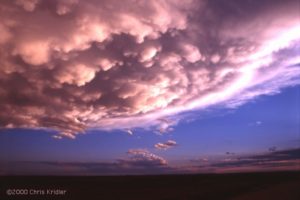
May 29, 2000, Nebraska
Monday, I chased with the entourage in western Nebraska. The storms looked mushy, but we watched one for a while that had a rain-free base and kept developing new and fascinating features. It was full of texture and shadow. It formed a wall cloud and then an anti-cyclonic couplet — the sort of rotating feature that could produce a tornado. But then it showed all signs of a gust-out as it kicked up huge amounts of dust as outflow appeared to take over. It was totally “Lawrence of Arabia” as billows of dust roared across the roads and rose high in the sky.
We ran into Matt Crowther and Betsy Abrams and decided that the storm wasn’t tornadic anymore and headed north to “better” atmospheric territory, but all we saw was Carhenge north of Alliance, Nebraska. Later a piece of the storm we abandoned broke off and reportedly produced a weak and dusty tornado. Such is life. We did see the most fantastic mammatus of my life on the way back to Sidney, Nebraska — a field of large, scalloped clouds hanging from the anvil of an otherwise unimpressive storm. The sunset cast this dramatic ceiling of clouds in golden light and architectural shadows. Gorgeous!
Yesterday was a big bustola as we went into eastern Wyoming and northeast Colorado. Early in the day, that area had looked good, but as the day went on, good old unreachable Iowa clearly seemed the place to be. Too bad it was too far away. Anyway, it was fun, as our already unwieldy entourage met up with several other storm chasers and loafed in a truck stop and along the side of a gravel road, hoping for a miracle, before heading back to Sidney, Nebraska, for dinner at Dude’s Steak House.
Today looks iffy. I will have to head back to Goodland, Kansas, to do some more reporting for an article for Florida Today, so I’ll do that sometime today. But if I can squeeze in a chase, I will.
GOODLAND, Kansas … June 1, 2000
The storm I saw today in eastern Colorado (thanks to Cheryl Chang for data) turned into a dust machine! It was the opposite of a vacuum cleaner. It was pretty from a distance, and it hit Goodland just as I was about to take my bags into the hotel, so I filmed it with the car door partly open. Dust got in EVERYTHING … I hope my camera survives. The entire inside of the car has a coating of dust. But I got a cool thing on video … the plant “greenhouse” outside the WalMart, which had plastic sheeting on a metal frame, was trashed by the wind as I was filming it. If only I could uplink to TWC … it’s their kind of video.
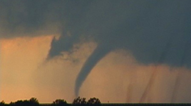
Here’s a collection of bulletins from the field, written during my 1999 storm-chasing trip in the Great Plains. They are slightly edited, but they give a sense of what it’s like to live life by the sky. Dates reflect when each bulletin was written.
May 11: Motel 6 in Denton, Texas
There’s nothing like hitting the ground running, or hitting the road driving. On Saturday (May 8), Dave Lewison and I drove from Baltimore to Springfield, Missouri, in order to be in range to chase storms the next day. That was Sunday, and we drove all the way to western Oklahoma and the Texas panhandle.
There was bad visibility — the storms fired in a mean, mushy line, so it was difficult to make out any structure. With the help of Allan Rosenberg giving us hints on the phone, we got in front of one storm and got some footage of it rolling into Quanah, Texas, then went south to Crowell. There, a rain-wrapped beast (i.e., it was impossible to see what was going on inside of it) was approaching the town. When the radio issued a tornado warning for the storm, which was practically on top of us, we scooted east darn quick, as it was getting dark and we couldn’t see what was happening. It was a radar-indicated warning anyway, which means there probably wasn’t an actual tornado involved.
The next day, after lunch with a couple of chaser pals, we headed to northern Oklahoma under partly sunny skies to see if storms would fire. On the way north on I-35, we passed a small portion of the F5 tornado damage in Moore, Oklahoma. It was staggering. Photographs can’t do it justice. It’s as if the neighborhood went through a blender. It’s humbling just to see it.
We reached our target town in northern Oklahoma. After much hanging around at a convenience store and the local Sonic drive-in eatery, we were about to give up … but still, we kept an eye on some aspiring cumulus to our north. And lo and behold, one of them started to look good — a firm tower was going up, so we turned north and began to pursue it. It grew a large anvil and kept building at the back of the storm, getting bigger and bigger. No rotation was evident, but it was a beauty, and as it sprouted a big anvil, the light from the setting sun hit its crown. We finally got close to it, crossing the border into Kansas, but could see no wall cloud (from which a tornado might form). Still, we watched it for quite a while as it got dark. It produced a great lightning show and then started throwing out quarter-sized hail. PLUNK! PLUNK! Worried about getting major dents, we booked out east ahead of it. Once we got far enough, we were able to park the car on a deserted farm road and take some lightning video and time-exposure photographs. Spectacular anvil crawlers were lighting up the sky, like iridescent spiders. The drawback: We got back to the hotel in Norman, Oklahoma, at 3 a.m.
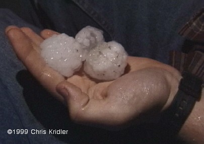
Hail, May 14, 1999
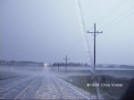
Hail in the road, May 14, 1999
Today, after another chaser lunch at another “trough” — the fond nickname for those popular middle-America cafeterias — Dave and I headed south for a slim chance of severe storms in north/middle Texas. We got ’em, all right, but were never in position to see anything really good. Then again, there wasn’t anything really good to see, except some lightning, torrential rain and a little hail. It was another day of driving hundreds of miles. The car has gained close to 3,000 since Saturday. And we’ve eaten dinner at Denny’s two nights in a row. Help!
Still, I’m happy to be out here on the open road, staring at the sky, living for the moment. And I have hopes for better storms later.
May 18: Super 8 hotel in Norman, Oklahoma
I know it’s a long time between updates, but I’ve been absolutely crazed. This is the first good down day I’ve had in ages. I’m actually grateful for blue skies today so that I can deal with laundry, bills, etc. I even had a SALAD with lunch today! Actual green leaves! You would not believe how much junk and diner food one consumes on the storm-chaser diet.
So … after a day of driving back to Norman last Wednesday, getting film developed, etc., I had a fun evening watching other chasers’ storm video, including Jim Leonard’s amazing footage of one of the May 3 tornadoes. It wasn’t the one that hit Oklahoma City, though he did see that storm at its genesis and got footage of it producing one tornado early on. But he jumped to another storm and captured a spectacular, large, white tornado moving through a field, with the texture of cotton candy.
Thursday, a three-person BBC crew hooked up with Dave and me. The BBC has lots of crews out here, following around chasers, scientists and so on. That day, we drove up into Kansas to get into position for the next day, because western Kansas/southwestern Nebraska looked good. Friday morning, the forecast wasn’t as obvious, as Texas looked to have potential too. But we pored over the data and decided it would have to be southwestern Nebraska, where a small clearing in the cloud cover would allow for daytime heating and thus provide fuel for storms.
It was a relief to get out of the clouds that were over Salina, Kansas, and into the clear. We paused at a truck stop to get more data and saw that a tornado watch had been issued for our target. That got us a little more excited, so we blasted northwest over some lovely, empty farm roads and into the area where storms were already starting to fire. We got close to one that had a tornado warning on it, but no apparent tornado — it quickly lost its organization and turned into a gust front, or rather a dust front, as huge, billowing clouds of red dirt blew at us. We tried to get into position to chase something better, but the storms were turning into a furious line and we ended up getting hammered by hard rain and small hail.
We stopped at a gas station to let the worst of it pass and saw the VORTEX research team buzz by. As the storm cruised past, the light was incredible, and a rainbow hovered before us as we sped off toward another tornado warning. No luck there, but the storms were a sight to see, sending lightning across the sky and glowering on the horizon.
Then, things got nasty. We decided to head for a town in Kansas to get into position for the next day and thought it would be a relatively easy drive. No such luck. The line of storms kept developing to our southwest, continuously pounding us, as we drove east, with fiercely intense rain and hail for, literally, hours. We briefly turned around a couple of times to avoid the big hail. When we resumed our course, we found so much hail on the road, it was like driving on gravel. It was even producing a “hail fog.” We stopped for a second and Dave picked up a few of the 1.5″ stones — and saw bigger stones by the side of the road.
In Stockton, Kansas, under yet another severe thunderstorm warning, we gave up and found an old motel. We got soaked running the six feet to the door to register. I felt bad for the BBC crew, who’d been following in their own van — I knew how exhausted *I* was from the drive, and they had never seen rain like that before.
The next day, Saturday, the forecast looked a lot more unlikely than it had the day before. The cloud cover, or “convective debris,” as the Storm Prediction Center so charmingly called it, was inhibiting the all-important daytime heating. We drove west for a ways, looked at the data again, and decided that any storms that might pop up would be garbage anyway. So we parted ways, with the BBC heading off to join another chaser and Dave and I beginning the drive back toward Norman, so that he could join Cloud 9 Tours on Sunday. Later, we found out that a tornado had occurred in the Stockton area, where we’d spent the night!
Sunday morning in Kansas, when Dave knocked on my door, it was clear that we were looking at big potential for storms, as there was lots of moisture in the air, it was sunny, and a cold front, low pressure and a diffuse dryline were setting up. He was willing to put off the tour a day — since the group wouldn’t be chasing, just having its orientation party — so we headed toward central Kansas. In Great Bend, a convenience-store clerk was nice enough to let us use the phone line to check the data. We picked a target slightly east of the center of the state, where the dewpoints and convective potential were nearly off the scale.
We fueled up in McPherson under “turkey towers,” skinny cloud towers that seemed to bode well for storm towers later on. The cap, or layer of warm air, hadn’t been broken yet, but the clouds were a good sign. We got a little east of the main area of convection, and then the sky began to explode. A few of the towers quickly began to build, breaking the cap and then shooting upward and gaining mass and strength. Their sheared appearance was a good sign of rotation. We kept up with the biggest one. Then I saw something suspicious — it looked like a funnel was angling out of the base of the storm. It took me a couple of minutes to convince Dave as we sped along, and finally, it was clear — a quick, distant, needle-like tornado, which caused some damage in Enterprise, Kansas.

May 16, 1999, mammatus
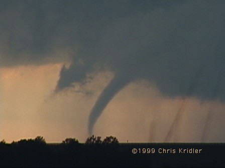
May 16, 1999, tornado
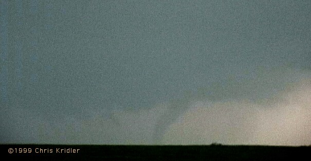
May 16, 1999, tornado
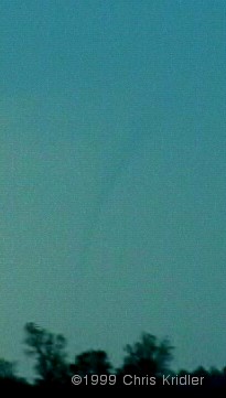
May 16, 1999, tornado
As that storm lost cohesion, we dropped south, where a whole line of storms was going crazy. We paused for a while looking at one storm and hearing tornado warnings, then dropped farther south to see a meaty-looking twister as tornado sirens eerily wailed nearby. Again, we only got several seconds’ glimpse — and again, my video stinks, since I was driving — but it roped out (got a snaky appearance in its dying stage) and for a moment looked like something out of “The Wizard of Oz.” We stopped on a farm road, where we met up with Don Lloyd, who’d had a good view and filmed it.
Again, Dave and I dropped south, driving through the town where the sirens were wailing, and pulled off on another farm road, keeping an eye on what looked like two areas of circulation. Then — one produced. It was a beautifully backlit tornado, and we managed to get a couple of minutes of video as it set down and then roped out. (No still photos; I was too distracted at the time! Plus it was a little distant; thank goodness for zoom lenses.)
The sun was setting fast, and the storms were aglow, but the ones we’d been chasing were losing their power. It was time to get Dave back to Norman. So we headed toward the interstate and, to avoid driving through another several hours of pounding rain, stopped in Wichita to get some food. We unwittingly stopped at a coffee shop in a flood-prone area. As the rain poured and blew in hurricane-like gusts, sky-ripping CGs (cloud-to-ground lightning strokes) were zapping the city, hitting nearby poles and disrupting the electricity more than once. As the torrent waned, the waitress suggested a route to avoid the flooding. But the alternate route was almost as bad. We managed to get through, but on a parallel street, cars were halfway submerged, their headlights barely showing in the water. And the huge drainage canal that runs parallel to I-35 was gushing, halfway full.
The worst of it was over for us, however. We made it back — another late night — and Dave joined the tour. Yesterday, I chased by myself but ended up seeing very little of the line of storms that went through Texas. They weren’t that exciting anyway, which was small comfort for wasting a day and using up a whole tank of gas when I could have been catching up on my sleep.
And today, at last, I’m doing laundry and errands and maybe even going for a swim in the pool. I also have to try to forecast when the next chase day will be. The pattern is quiet right now.
May 23: Motel 6, Hays, Kansas
This trip is going by so quickly, it’s hard to remember what day is what. But May 20, Friday, is an easy one to remember.
I was chasing on my own. I headed from Norman, Oklahoma, to Shamrock, Texas, to check data at a truck stop, where I ran into some old friends from Cloud 9 Tours. After a nice reunion and another run-in with another BBC crew that was following the group (they’re EVERYWHERE!), I decided to head west on I-40 a bit, where many elements were in place for severe storms. Among them, the dryline was pushing into the Texas panhandle, and a small line of cumulus clouds was appearing on the satellite image, so it seemed like a good place to start.
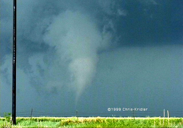
May 20, 1999, tornado
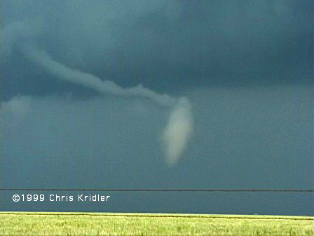
May 20, 1999, tornado
Almost as soon as I reached my target, I saw towers going up. I drove a little north on Texas highway 70; one storm quickly died, but another slowly built, evolving, sucking in moisture, growing a “beaver tail” cloud formation, hinting at lowerings. I wasn’t convinced that it would do anything, but since it was currently the only show in town, I decided to stick around. I seemed to be the only chaser in sight, though I eventually saw a couple of VORTEX research vehicles.
Then the storm starting cranking, showering me with small hail and picking up speed — as well as moving south, which is very unusual and indicated that this storm had potential to produce something more than rain. I met Tim Marshall, a well-known chaser who runs a magazine called Storm Track, and then, all of a sudden, there were about a HUNDRED chasers on this storm! It was unbelievable. Lots of geeky cars bristling with antennas, leap-frogging as they pulled off the road and pulled back on.
Just north of the Interstate, those of us who had waited to flee the storm were rewarded with an up-close-and-personal look at a strange white tornado to our east that touched down briefly in a field and then stretched out weirdly as it dissipated. It was beautiful. As the clouds churned overhead, I decided to head south again to avoid having a gustnado (a little spin-up; I had already seen one) land on my head.
South of the interstate, I saw two more well-developed funnels form, though they didn’t touch down that I saw. At one point, it really looked like the storm was getting its act together to produce a big tornado, but it did not. Still, more tornadoes were reported on it; though I was on the storm the whole time, I didn’t see those. It was a huge storm, so it’s conceivable that something formed out of my sight.
I counted myself lucky, because I wasn’t stuck in the hail core. The Cloud 9 group, which had headed south when I went west, ended up having to approach the storm through the hail. Though the group saw the tornado, a couple of the vans were dented up and lost windshields to 5″ hail! That’s HUGE. We’re talking grapefruits. I wish I had seen the hail, but I’m glad my car didn’t have to experience it.
I had a down day on May 21 and took the opportunity to hike in beautiful Palo Duro Canyon, just southeast of Amarillo. I took lots of photos of wildflowers and blooming cacti, and tried to capture (on film) a keen green lizard. Then I drove to Garden City, Kansas, to get in position for yesterday’s chase.
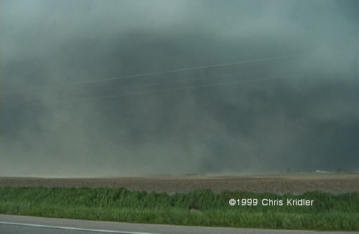
May 22, 1999, “Dust Bowl” storm
I probably should have stuck to my original forecast yesterday — for northwest Kansas — but I was lured by upper wind divergence and ended up heading a little farther east. Storms were going up everywhere. I picked a really meaty one and headed north into Nebraska to intercept. It turned into a spectacular gust front that kicked up great walls of dust before it. It then chased me back into Kansas. I’ve never seen green in a storm as I did in that one — there was literally a kind of teal color within. The color and reflectivity almost certainly meant big hail, so it was important for me to keep ahead of it.
I chased, or was chased, for a couple of hours and stopped to take photos of the amazing shelf cloud the storm developed. It took on a fantastic layered appearance as it crunched south. I parked by a lake to get a couple of photos and told the people fishing that there was a severe thunderstorm warning. All left, but then a couple of anglers arrived and didn’t CARE that there was a warning. “Oh, I’ve seen worse,” one old guy said as lightning struck nearby. DUH! Fishing poles. Flat lake. Lightning. You do the math.
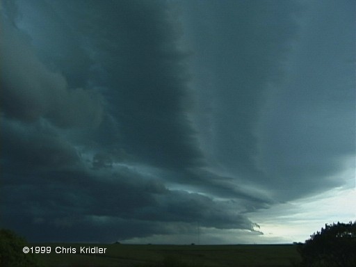
May 22, 1999, shelf cloud
Eventually, this south-moving storm collided with some east-moving stuff, and as darkness fell I got a room in Hays, Kansas, for the night. There were a few confirmed tornadoes yesterday, says The Weather Channel, though of course I didn’t see any of them. But I did see quite a show.
Today, I probably won’t chase. The prospects are slim and distant (in New Mexico). Maybe I can finally get in that movie — what’s it called — you know, the one with the spaceships …
May 27: Motel 6 (yet another one!), Fort Worth, Texas
Well, the trip is more than two-thirds over, and I’ve put more than 8,500 miles on the car. I’m truly sick of diner food. But the wonderful storms keep on coming.
I drove in a big circle on May 24 from Amarillo, Texas, to Roswell, New Mexico, and back into Texas, seeing cloud towers corkscrew and collapse all day. I should have stuck to my original forecast — closer to Roswell — because that’s where there was a tornado warning. (Plus, maybe I could have seen a UFO.) That’s OK; when I arrived at my hotel in Lubbock, I got to experience a line of severe storms that ran over the city. There was some very intense lightning (one cell-phone tower was zapped four or five times) and heavy rain. I met a few chasers from Illinois who were also at the hotel. They had never chased Great Plains storms before and were finding out that the weather out here is a very different beast.
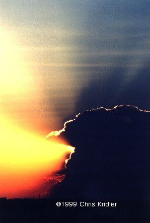
May 25, 1999
The next morning (May 25), since they didn’t have a laptop, they looked at my data, and we ended up chasing together. We stopped in Clovis, New Mexico, for more data and ran into one of my pals from the storm-chasing tour last year, Tom Warner. The whole caravan headed west into what soon became a forest of supercells in eastern New Mexico and west Texas. We picked a cell with a severe thunderstorm warning on it, in hopes that the shearing conditions would prompt a tornado. It was a classic supercell, but the tornadic storm far to its south was probably robbing it of moisture, preventing it from gaining strength. We watched it for a while, then fled its onslaught of hail and decided to chase a cell east of us. We never caught it, since it was moving east; we ended up between two lines of strong storms, though we could see their amazing towers and anvils from great distances. We went our separate ways, and I ended the day east of Lubbock, videotaping lightning well after dark in a cell that eventually had a tornado warning issued on it. (I didn’t pursue it; it’s hazardous chasing such storms at night!)
On May 26, I met up with the Illinois chasers again, and we ran into a chaser convergence at Big Spring, Texas. On hand was the Silver Lining Tours group, as well as Dr. Howie Bluestein of the University of Oklahoma and his mobile radar. I introduced myself to him since I’d once interviewed him for an article. After getting data at Midland, Texas, and running into more chasers, we headed west to keep an eye on a cell coming out of Carlsbad, New Mexico. Few road choices and the momentary allure of another cell meant we weren’t close to it when a “tornado on the ground” warning was issued. We came back to it from the east. Under a nice wall cloud, a very suspicious-looking lowering formed. I reviewed my video, and I think it was possibly a tornado, but I can’t say for sure. We couldn’t stick around long enough to examine it or get closer because, for one, it was becoming rain-wrapped and thus invisible, and two, the storm was beginning to form a vicious, hail-filled gust front that was already looming over our heads, cutting into the sky like a giant black spaceship (think “Independence Day”). We turned tail and zoomed east at warp speed, but not before we spotted Dr. Bluestein’s mobile radar vehicle roaring west toward the heart of the storm — perhaps toward the gap between the lowering and the hail core. We ended up in Crane, Texas, where we waited out the front and saw some truly spectacular lightning, the best I’ve seen this year.
Today was an off-day. I met up with the BBC crew again for a wrap-up interview. The “bad” weather should start again soon — I hope.
June 1: Guest Inn, Norman, Oklahoma
It’s funny how the prosaically named Norman has become a kind of second home. I know where the laundry is, I know where the post office is, I know where at least some of the restaurants are. Though they all close early — I had to go to Denny’s again tonight. You know, I’m starting to LIKE Denny’s. Egad. Tonight, the Sunshine Slam with hash browns and a side of fruit — fat banana slices, fork-repellent purple grapes and juicy red strawberries. Not bad.
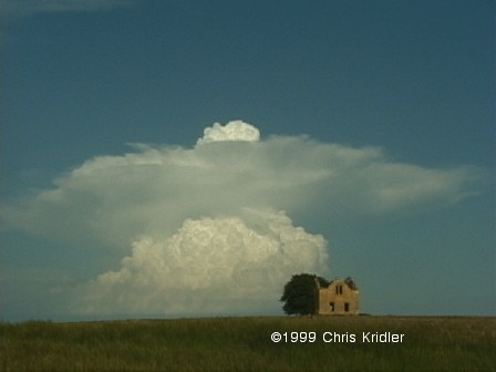
May 30, 1999, Kansas. I have a better non-video pic of this too…
I’m between chases (at least I hope I am — at least that would mean I would end my trip chasing). The last few days have involved a lot of driving with mediocre results. But looking at the bright side, on Sunday, May 30, I ended up taking a lot of pictures of gorgeous popcorn storms in central Kansas. They started out as silly-looking mushrooms and narrow corkscrewing cloud towers, bright white against the blue sky. I ran into a couple of other chasers by an abandoned house that was a perfect foreground element for photos. Later, a couple of the storms became severe. I followed one till well after dark, which was easy to do thanks to a full moon and its isolated nature. A spotter reported a tornado on the ground with that storm, but at about that time I saw lightning illuminate a “scudnado” — i.e., scud clouds in a suggestive shape, but definitely not a tornado. Then a line of storms that had formed in Nebraska swept down through Kansas; I took refuge in a car wash in a small town while it went through. The winds and rain were intense.
Yesterday, May 31, was a day of frustration, as many tornadoes were expected but only a few appeared and were seen. I didn’t see any of them, though I was definitely in the “hot zone” as far as lightning was concerned, as I was cornered by a great beast of a storm. Around sunset I intercepted the storm that had produced a couple of the tornadoes, but for all the time I watched it, it produced no more. At least one more was reported later, after dark, when I had abandoned it. The footage on The Weather Channel of the one large but short-lived tornado was very annoying!

June 1, 1999, rainbow
Today I chased on a slim chance of severe storms, again intercepted one with a radar-indicated tornado warning as I dropped south from eastern Oklahoma into Texas and back up again, and though I saw some suspicious lowerings including what looked like a funnel, an incredible double rainbow, corkscrewing supercell structure and some golf-ball-size hail, again I saw no tornado. And I just saw on TWC that some were reported just north of where I was (with more irritating tornado footage). ARGH. I feel like an idiot. My only comfort is that it’s really hard chasing in eastern Oklahoma, what with the hills and trees, so even if were on the right storm, I might not have seen anything anyway. The sky was incredibly difficult to read today — a huge line of towering cumulus formed along the cold front, which extended from Texas up into the northern Midwest.
In pop-culture matters — well, pop culture is hard to find out here. In trying to listen to storm warnings on the radio over the past few days, I have become intimately familiar with the country music top 40. Please kill me.
I also have to have my say regarding the new “Star Wars” movie, which I saw on Friday. Here are a few points I feel compelled to make:
Jar Jar Binks: Stinks.
Queen Amidala: Bland, OK, but incapable of opening her mouth all the way when she speaks. Is it the lipstick?
The plot: Hopelessly transparent. I can’t believe they’re going to wait to “reveal” the villain.
Samuel L. Jackson: I love this guy. He has about two lines. What’s up with that?
Best scene: The pod race. Excellent intergalactic “Ben-Hur” ripoff.
Ending: Way too chipper. When in the hell is the Dark Side taking over?
Biggest absurdity: The Darth Vader virgin birth theory.
Overall: Flashy. Lacks gravity. Good moments. Basic fun. Cute Anakin. Cuter Obi-Wan. B-.
I’m sure you didn’t need that movie criticism, but aren’t you sick of reading about thunder and lightning? I haven’t posted any new photos. I’ve been too tired and driving too much. Almost 11,000 miles on the car this trip so far.
June 7, 3 a.m.: Home, Glen Burnie, Maryland
What would possess two storm chasers to delay their trip to the East Coast and drive 27 hours straight from the Nebraska-South Dakota border? A “high risk” chase day, that’s what.
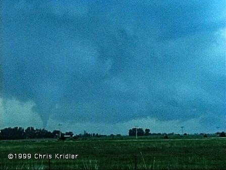
Tornado, June 5, 1999
It had been a frustrating week. Wednesday, June 2, I chased on what was supposed to be a good day in the Texas panhandle but turned out to be a line of severe storms wrapped in rain. There was a tornado I didn’t see, many miles south of me, that was apparently visible for about 30 seconds to the VORTEX research team. I could see almost nothing in the storm I got caught in, except I got hurricane-like video of trees blowing in the gale. And a gorgeous sunset and rainbow followed. June 3 in southern Kansas and the Texas panhandle was a super-bust — in fact, the only “dry bust” — i.e. no decent storms at all — that I had all month. Friday, June 4, I ended up hooking up with an entertaining caravan of fellow chasers from Wisconsin, Colorado and New Jersey and chasing storms in western Nebraska. The storms didn’t look that great, so we gave up on them. Of course, the ever-persistent VORTEX research team managed to get a couple of tornadoes just after dark in an area with virtually no roads. Most of us were puzzled as to how, but I think it has something to do with the whole idea of no results, no government funding. Or perhaps their cars have wings.
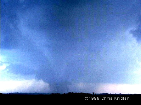
Tornado, June 5, 1999
Saturday, June 5, my pal Dave (who had been hanging out with Cloud 9 Tours) and I were supposed to drive back to the East Coast, but we couldn’t resist chasing the “high risk” day, as designated by the Storm Prediction Center. We knew the elements were coming together for a “PDS,” or a particularly dangerous situation. The only foreseen problems — the storms would be widely scattered, and they would likely be screaming northward instead of cruising east or northeast as usual. As on the day before, there were incredibly strong upper-level winds coming from the south. That meant we had to be able to intercept the storms, because chasing them northward would be like trying to catch a galloping horse on foot.
Mobile Doppler, June 5, 1999
We left the Cloud 9 group — I had to meet up with them that morning to retrieve Dave — but ran into them again at a truck stop in southern Nebraska on I-80, along with a bunch of other chasers. This chaser convergence is not at all unusual. Sometimes it’s fun, but at other times it’s irritating or downright dangerous if too many are on a storm. At this point, we were just all figuring out where to go. Dewpoints were near 70 in eastern Nebraska, which meant explosive potential should storms go up there. But there were also signs that they could initiate farther west. At the least, Dave and I knew we had to go north into the better air, and where we could intercept northern-moving storms. Near the area where we thought we might turn west, we spotted an area of cloud towers trying to form to the north. Soon one of them became a quickly sprouting bomb, and we began pursuit. It must have been moving northward at a very fast pace, because we could never quite catch it as we blasted into northern Nebraska — and then it died.
We were at a loss and without information on where other storms might be firing, though we saw another anvil from a storm to our southwest and were tempted to go after it. At least we would be intercepting it FROM the north. Tim Samaras, a fellow chaser with a satellite dish, confirmed what we saw — the cell we were seeing was the only one for miles around, it was big, and it had potential. When a storm is alone in such a juicy environment, it tends to go crazy. We went west to intercept.
As we got near it, we took a south road and paralleled it for a while. It had a beautiful structure, a hard convective tower that showed it meant business, and it seemed to be trying to organize a wall cloud (from which a tornado might form). But we had to get closer to be sure, so it was back north and then west through the town of Bassett. The storm was moving north at an amazing rate, possibly 50 miles per hour. It was catching up to us very quickly. We stopped just west of the town as the base of the storm approached the road and focused on a developing mesocyclone, or area of rotation, within the storm. It took us a moment to realize that a much more impressive meso was developing practically over our heads — a large, clearly rotating area, and we were under the northeastern edge of it. On the opposite side of the meso, we suddenly saw it — a funnel forming rapidly in the rain. It touched down — tornado! — and moved out of the rain to the east and north toward the town, kicking up debris as it went. It had a healthy condensation funnel and was clearly chowing down on the Nebraska earth. After a minute or two it began to weaken and rope out, and as the meso was now over our heads, we booked east. Dave got amazing video of the top of the now-skinny funnel protruding from the storm almost directly over the car, which I was driving, while the base of the tornado was still kicking up dust south of us.
Once we got out of the danger zone, I noticed a big new meso just to our north — the storm was moving northward, and fast. We were going to head north but changed our minds and headed east, just in time to catch an even bigger tornado north of the road. It, too, didn’t last more than a few minutes, but it was impressive (even if Dr. Howie Bluestein, mentioned in a previous bulletin, parked on the wrong side of the road between us and the tornado with his research vehicle while we were filming). I haven’t looked at damage reports yet, but I don’t think the twister hit any houses (I heard it struck some chickens, however!). And unless a tornado hits a well-built structure, it’s difficult to characterize its strength. However, Jim Leonard, who saw it too and has been chasing for more than 25 years, said it could have been as strong as an F3.
We tried to play catch-up with the storm and managed to see more signs of rotation. We even cut through the edge of the rain core to get ahead of it. But we saw no more tornadic action. The sun had set, the light was failing, and the storm was hurtling north at probably 50 miles per hour. Helicopter, anyone? We ran into Cloud 9 and a couple of other chasers (there may have been 20 or more cars on the storm at any one time) and compared notes, then marveled as the cell was lit up by lightning while stars shown above it. The vacation ended not with a whimper, but with a bang. And with the aforementioned 27-hour trip back, which began immediately after the chase. Remind me not to do that again.
Summing up the trip: 6 (maybe 7) tornadoes, a few funnels, an amazing month of storms. Lots of Texas dust and 12,000+ miles on the car. 14 hours of video. An as-yet unseen cellular phone bill, but I may need resuscitation after I get it. And about 4 hours of sleep in the past two days.
The following is a collection of six e-mail bulletins I sent to friends while I was chasing storms in spring 1998. I spent a month in the Plains — a week chasing on my own, two weeks with Cloud 9 Tours, and a week on my own again — and saw a fair number of storms, despite the uncooperative weather. Please note that the dates indicate what was imprinted on the e-mails and so may reflect a slight delay from when I wrote each bulletin.
Contents copyright 1998-1999 by Chris Kridler
Wednesday, May 13, 1998, 4:15:52 AM
I got into Oklahoma late Sunday night after a 15-hour drive from points East, and the last thing I wanted to do was drive way up into Nebraska the next day. But I thought, what the heck, that’s what I’m here for, right? I went up US 75 from Henryetta, OK, trying to at least get into the area at risk for severe storms. I was grateful to see clouds, at last, in northern Kansas, but no convection was evident and I hadn’t located a place to plug in my laptop to get more data. So I relied on an AM radio report of a tornado watch and headed west shortly after I got into Nebraska.
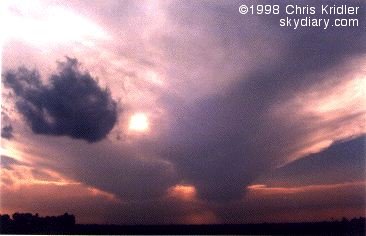 I nearly gave up hope when I saw the tattered remains of a big storm, but I soon realized that several more were building. I headed further west toward one of them, and soon the radio station I was listening to was citing a Doppler-indicated tornado warning. But by the time I got near the storm, the warning had expired. Still, the lightning was amazing, and it was clear that major action was occurring, as I noticed another big “anvil” (blown off the top of a storm) to my south.
I decided that to intercept that storm, I should head south. Not too bright. I ended up right in the middle of it. Stunning lightning was striking far too close for comfort, and I was hammered with fierce winds, a blinding deluge and small hail. The clouds above were starting to look a little TOO interesting (since I was right under the roiling monster and didn’t know what it was going to do), so I was kind of grateful when I escaped its clutches. I ended up west of the storms. The view was breathtaking — huge cloud towers the color of Orange Creamsicles as the sun set, a fresh breeze, the birds twittering and a fantastic lightning show. Later, the full moon rose above the storms, still sparkling with lightning.
Today, I came back to Oklahoma… but it looks like I’m heading back up to Nebraska again tomorrow. (For the record … I wasn’t the only chaser who headed south only to find that the two-day forecast called for severe storms in the Northern Plains.) I need a chauffeur.
Meanwhile, I’m already sick of fast food and Waffle House-type establishments. There’s not enough garlic or Romaine lettuce in middle America.
Friday, May 15, 1998, 5:08:31 AM
Well, some days storm-chasing sucks. Take the last two days, for example. I put, say, a thousand miles on the car and saw far too much of western Oklahoma and the Texas panhandle, and for what? Well, let me tell ya.
Yesterday I didn’t really expect to see storms in theTexas panhandle, but in my driving around I saw a few cool, kitschy landmarks (a giant dilapidated cafe sign shaped like the state of Texas, for example). Clouds tried to build toward the end of the day but were flattened by the “cap” (temperature inversion). So I stayed at the lovely Motel 6 (NO WEATHER CHANNEL! the horror!).
Today, there was a much better chance for severe storms … a chance that got worse and worse as the day went on. I drove in hundred-mile circles around the Texas panhandle and western Oklahoma, trying to find the storms that were supposed to fire on the dryline. The cap was fiercely prohibitive, sitting on the clouds like a giant elephant. Making things especially difficult was a thick haze (and I thought Baltimore was polluted), the result of smoke from fires in Mexico and Central America. I was desperate. I saw some wandering chasers. I stopped for gas and ran into another storm chaser who hadn’t seen anything either. But a look at the radar (yes, he has two satellite dishes in his truck, ladies and gentlemen) revealed a tiny line of storms headed our way.
Here’s why this sucked. One, it was almost sunset. Two, the haze was blinding. In other words, there were storms (we even saw the billowing top of one), but because of very limited visibility it was pointless to go after them. Chasing severe storms at night is just dumb. They hammer you, and you can’t see anything anyway.
So, my friends, this was what storm chasers dread: a BUST! The worst kind of bust: a near-miss.
Thursday, May 21, 1998, 3:13:10 PM
If you want to know how bad food can get, go storm-chasing. Last night, in the thriving metropolis of Sidney, Nebraska, everything had closed by 10 p.m. And that meant truck-stop convenience-store food for dinner after a long day on the road. At least they had apples.
I’m with the Cloud 9 Tours group now for a total of two weeks. Despite what some chasers are calling a “thermonuclear cap” (the giant high pressure system that is only now inching eastward), we’ve had a couple of fun chase days already, driving all over eastern Colorado and southwestern Nebraska. We’re in the mountain time zone at the moment. In the slightly higher altitude here, it’s easier for the cap to break, allowing storms to form. And the front draped across the northern part of the country is helping.
On the way north Monday to get into position, we stopped to take photos of lightning and ended up driving through a storm that produced 55 mph wind gusts before we got in the cars … the winds were most certainly higher when we were driving through it. Tuesday we saw a few storms fire and fall apart, but they were pretty. Then, yesterday, we saw the best action so far: a huge rotating supercell that kept teasing us with lowerings and “wall clouds” (where a tornado is likely to form) … but it didn’t produce a tornado. Still, it was gorgeous.
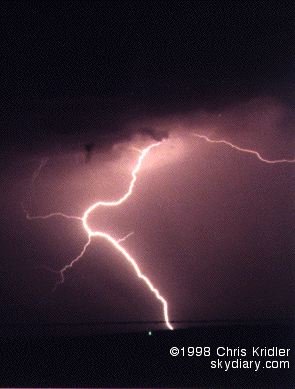
May 18, 1998, Kansas lightning
The weirdest thing about the tour so far is that a National Geographic crew is following us around, constantly sticking cameras in our faces and holding big fuzzy microphones above our heads in an attempt to eavesdrop. I was videotaping a storm Tuesday, turned around and found one of them right at my elbow with a big camera. Scared the hell out of me!
Looks like we’ll be chasing in the same general area today … or maybe a bit farther south. If the storms keep getting progressively worse, dare I hope for a twister by week’s end? Nah, better not. Then it certainly won’t happen.
P.S. I didn’t win the $195 million Powerball lottery. Rats.
Monday, May 25, 1998, 7:51:45 AM
Today — Sunday, May 24 — was the day the will be hard to beat.
We started in Norman, OK, with the idea of an almost leisurely drive of a few hours to a target area in northwestern Oklahoma. A stop to get some data in western OK in mid-afternoon showed that we should revise our target area a bit, so we aimed for Woodward, where in 1947 a giant tornado killed more than a hundred people and devastated the town. Woodward was lucky yesterday, but as we drove through the town we saw a big storm going up to our east. We had had “busts” three days running, and it seemed as if storms would never break south of the stationary front that’s been draped across the plains. Today, they broke.
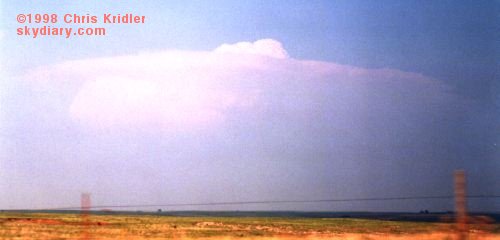 The storm was a loner. That’s an encouraging thing, because no other storms were around to steal its energy (or steal its thunder). It was feeding greedily off the heat and moisture that had been building in the atmosphere and was soon a big fist sticking up. Then it mushroomed, growing in mass and spitting out a big circular anvil at its crest. An overshooting top showed a strong updraft. This was a monster in the making.
We struggled to reach it as quickly as possible. Usually it’s best to see storms from the east, so that you can get into the best position as it goes by. But we had to approach it from the rear — from the west — and it’s lucky we did. This storm bordered on being an “HP bomb” — a high-precipitation monster that was likely to obscure its features with rain. We got into the heart of the storm before the rain hit us and were treated to a quick “gustnado,” a little tornado-ish thing that spins up but isn’t necessarily associated with the mesocyclone, or rotating area of the storm. Then, rapidly, two small tornadoes spun up in succession. They almost looked like big dust devils.
Then we got the really cool tornado.

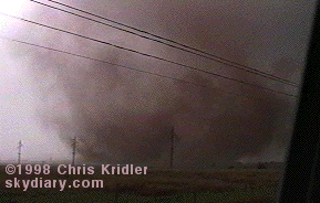 Though it wasn’t particularly strong, it was dramatic — it spun up a big bowl of dust just north of the road and soon was writhing with dark reddish-brown tendrils. It looked as if it was going to cross the road just east of us. Everything was happening very quickly. And then the wind knocked over a telephone pole about 25 yards in front of us and the tornado turned south-southwest — headed right for us. We were in the “bear’s cage.” The other tour van, which was east of the tornado, zoomed east away from the twister as it got within a hundred yards of us, making our big van shudder with strong winds. We got turned around, briefly spun our wheels in the slope off the road and sped west away from it. It was thrilling. It soon crossed the road, weakened and died. Another small tornado spun up south of the road, which was filled with a sudden convergence of storm chasers and cops.
We decided to head east to see if we could get around the storm and meet up with the other van, but complicating factors came into play — a couple of cops, completely clueless about what the storm was doing, slowed down the traffic by driving slowly in front of it. And as another big wall cloud (a lowering in the storm) began to show threatening funnel tendencies just south of the road, it became rain-wrapped — we were in the precipitation core, and soon we could barely see anything.
The cops let us go eventually, and we ended up driving through heavy rain and golf-ball- and plum-size hail, which repeatedly hit the van with big CLUNKS! We have a couple of good dents to prove it, and we stopped at a gas station to let some of it pass over us. It was chaotic. We took off further east, and it was getting pretty dark by this time — too late to chase storms safely, especially tornadic storms. North and west of us were also tornado warnings. As we drove down the road, I was in the front passenger seat of the van shooting video out the front window. Then… BLAM!
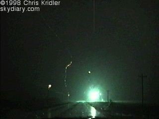

Lightning hit three telephone poles simultaneously in front of us — two on the left, one on the right. Sparks showered from the transformers. I got it on video. It’s rare to capture something like that on tape. What a rush!
The flash was amazingly close. On my video, when the lightning strikes, there is first a frame that is white — completely filled with light. Two bolts are apparent in the frame shown above, though sparks showered from three telephone poles. It’s possible that two poles were hit, one on each side of the road, and the charge on the left side traveled up the power line to cause sparks to shower from two transformers on the left, or north, side of the road. In one frame, you can see the remnants of the lightning and showers of sparks.
We eventually reunited with our colleagues, took a few lightning pictures when we got ahead of the storms and headed “home” to dinner and our hotel in Norman.
Friday, May 29, 1998, 2:17:24 PM
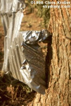 SALINA, Kansas — We’ve had a couple of days of BAD weather. Sunny skies, high heat. There’s a chance of storms today, but based on the data, I’m not getting my hopes up. Still, a couple of days ago, I got to see what the effects of an F3 or F4 tornado are really like.
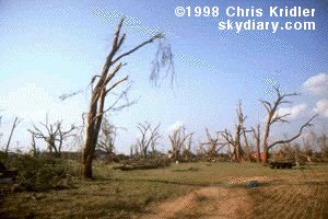 Our group went to Lamont, Oklahoma, where a half-mile-wide tornado — spawned from the same storm that produced the tornadoes we saw — seriously damaged several houses and blasted trees so that they looked as if they’d been through a firestorm. I saw the kind of legendary tornado “tricks” that people talk about — including pieces of hay and corrugated metal shot into trees.
Sunday, June 7, 1998, 2:32:58 AM
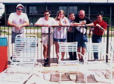
Cloud 9 Tours chasers
I wrapped up my last week in Tornado Alley with a truly pathetic chase … but then again, there wasn’t much more available to me. This season has been dreadful!
Wednesday I ended up in Joplin, Mo., thinking I’d be in position for a chase the next day. Thursday morning, it looked to me like extreme mid-eastern Oklahoma and northwestern Arkansas would be a good place to chase — except that the geography makes it a very bad place to chase! Hills, mountains, trees — very pretty, but impossible to see anything, and the road network is abysmal. Still, the data showed some potential and I was desperate. I began the day with a leisurely drive south through the Ozarks. When the Storm Prediction Center started talking about “significant supercells” and using the “T” word, I began frothing at the mouth. Or maybe it was the vanilla milk shake at the truck stop in Fort Smith.
I roamed north and saw some pretty convection in the Bushy Mountains area of eastern Oklahoma. It soon appeared the cap was breaking with towers to my northeast. I crossed into Arkansas, but what looked impressive quickly proved to be fool’s gold. I was in the middle of the tornado watch when it was issued, but a lot of good it did me! I saw little more than hard rain and a few brilliant CGs (cloud-to-ground lightning), though several severe thunderstorm warnings went out and somebody reported quarter-size hail. It was a very messy cluster of storms along the cold front, and what storm structure there was was difficult to make out.
I probably should have chased in Texas Friday, but didn’t deem the chances for big weather thrilling enough … especially since I had to drive home sometime this weekend (and I just know all hell is about to break loose in the Panhandle, now that I’ve left!). Like a possessed person I drove straight through from Joplin to the Baltimore area in 17.5 hours. It’s cool here, mostly sunny, and I’m desperate to return to the Plains. However, I got my first decent sleep in a month, got my sushi fix, and found out that I even lost a couple of pounds on the chaser diet. Small comfort for vacation’s end.


