Chris Kridler
Chris Kridler is a writer, photographer and storm chaser and author of the Storm Seekers Series of storm-chasing adventures.

Chris Kridler is a writer, photographer and storm chaser and author of the Storm Seekers Series of storm-chasing adventures.
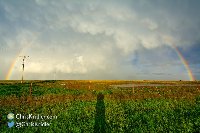
I followed storms east in the Oklahoma Panhandle to be treated to a great rainbow and mammatus. This is “The Rainbow and I,” with my shadow.
Roll over each image to see the caption, or click on one to see a slide show with larger photos.
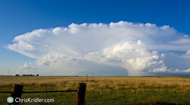
The hail core on this storm was beautifully green.
Roll over each image to see the caption and the story of the chase, or click on one to see a slide show with larger photos.
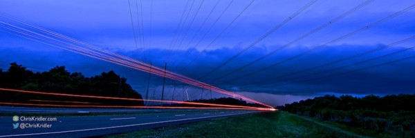
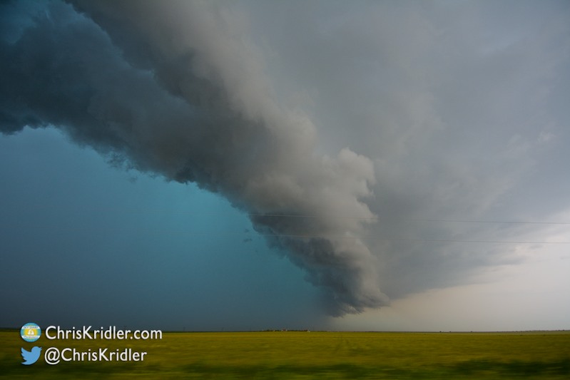
I loved the lines here: power lines, the laminar shelf cloud and lights on the road, with a bit of lightning in the background. Shot west of Cocoa, Florida, on April 13, 2015. Photo by Chris Kridler, ChrisKridler.com, SkyDiary.com
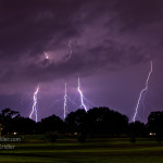
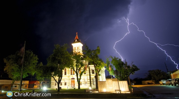
Lightning over Rockledge Country Club. Photo by Chris Kridler, ChrisKridler.com, SkyDiary.com
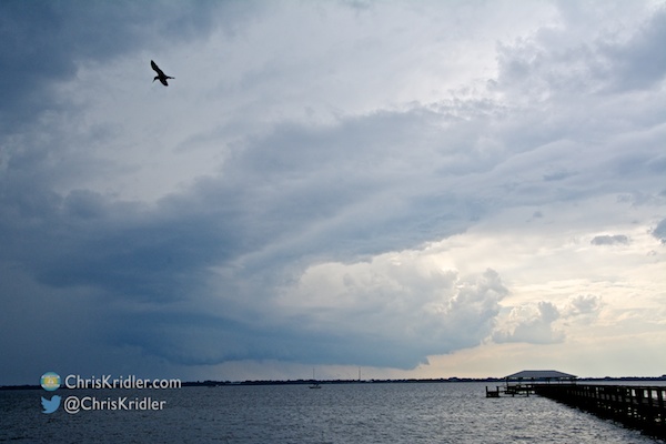
Still, there’s nothing more therapeutic than standing by the ocean, listening to the waves and thunder, while trying to capture a lightning bolt with my camera. Check out all the April storm photos below.
Stay tuned – the Tornado Alley chase is coming soon!
Roll over each image to see the caption, or click on one to see a slide show with larger photos.
It’s been about a year since I chased tornado-warned storms in central Florida. This is one of the most popular videos on my YouTube channel. Of course, I didn’t see any tornadoes, but there was some awesome cloud structure on March 29, 2014, that sure looked like one for a minute.
A severe storm approaches Melbourne Beach, Florida, on March 26, 2015. Photo by Chris Kridler, SkyDiary.com, ChrisKridler.com
My chaser friends are starting to buzz about the season to come. Will there be an early burst of activity in May? Will the more serious severe weather pattern kick in later? Now the suspense begins. I’ll be posting updates here and at SkyDiary.com, my storm-chasing site, as I chase storms in Florida and in Tornado Alley. Stay tuned.
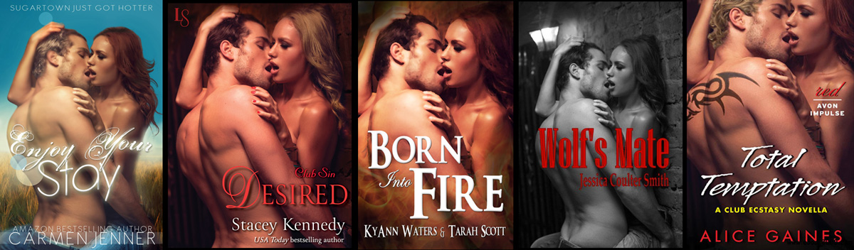
All of these book covers use the same photo, manipulated differently, illustrating the perils of stock photography. Or do readers really care? (Click through for a larger version.)
Book covers fascinate me, especially for fiction. They’re a portal into a story and can be as creative as the novel itself. Sometimes, they’re so creative, you have no idea what the book is about, especially when it comes to literary fiction. They can be art unto themselves. But does the cover matter?
I’ve decided that it does, and it doesn’t. I’m designing covers now for a romance series that more or less falls into the New Adult genre. (That’s a fairly new genre defined in different ways – but it’s loosely about college-age and twenty-something characters, often romantic, possibly angsty and sexy.) Honestly, genre definitions make me crazy, because I always seem to write across the lines, and covers are seen mainly as marketing tools that let readers know what they’re getting. Look at any genre, from political thriller (the White House at night) to Regency romance (ooo, pretty dresses!), and you’ll see easily identifiable image and design similarities within.
That said, I asked folks on Facebook what helps them find new reads while browsing online: Cover art? Category on sites like Amazon? Or something else? I was asking about first impressions, of course, because after that first impression, reviews also had an impact on buying decisions.
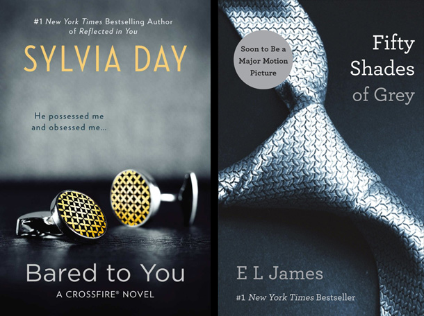
The legacy of “Fifty Shades of Grey”: the symbolic billionaire book cover, as seen on Sylvia Day’s Crossfire novels.
It wasn’t a scientific survey, but the answers surprised me a little, mostly because they were so mixed. Some looked for category first. The promotional copy – the “blurb,” as many called it – often took precedence over the cover. If the cover was a factor, it was just a gateway to more information about the book that helped a reader make a decision. Title was a big factor, too.
But having a bad cover is almost always a turn-off. You can have the best reviews in the world and the slickest summary, but paired with an unprofessional cover, all those good words count for naught.
I’m not sure if my question got me any closer to resolving my quandary: What kind of cover should a New Adult book have, if it’s also a steamy romance (as many of them are)? I’m fascinated by looking at what’s out there now. Sylvia Day’s Crossfire books (and many of her other titles) clearly draw on the Fifty Shades of Grey
presentation of an isolated object on a dark background. There’s an implied swanky opulence as befits the rampant billionaire bad-boy theme. That said, her self-published version of Bared to You,
pre-Penguin-publishing contract, featured a stock photo with a sexy couple that was artfully shadowed for the cover; a high-heeled shoe appeared on the U.K. cover. (See them here.)
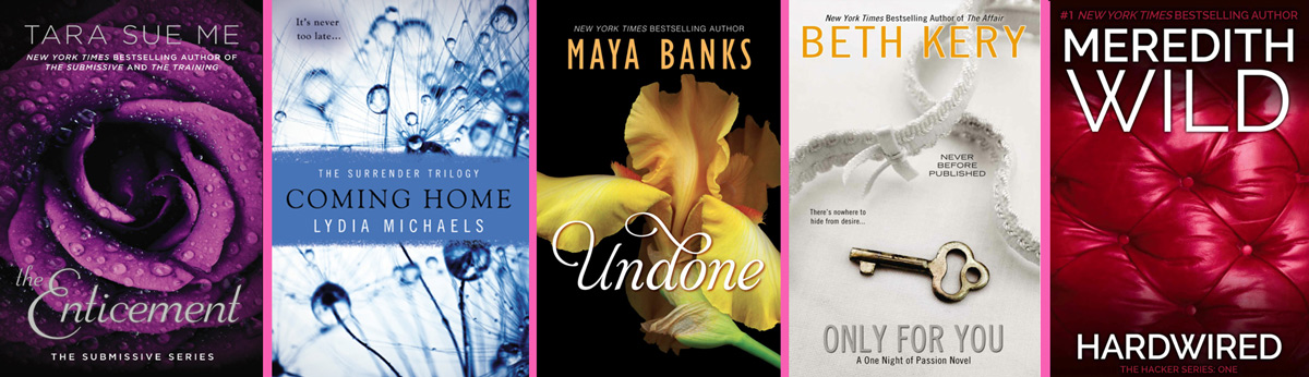
Are abstract or symbolic covers for New Adult and steamy romances as enticing as skin? At the least, they’re intriguing. (Click through to see a larger version.)
Her books fit into what I consider a subset of New Adult. They are New Adult/erotic romance. And in that genre, abstract or symbolic covers (featuring fabrics, flowers, liquids, keys) compete with covers showing scantily clad people, especially men who spend way too much time at the gym. Why the sexy dudes? Apparently, they sell books. Do they sell as well as the pretty, non-people covers? For an unestablished writer, probably better, is my guess, but I have no data on that. The sexy dudes range from well-dressed men in ties to darkly lit, scary, young (and clearly troubled) guys in hoodies who are probably into mixed martial arts.
Now that I’m attuned to such images and have browsed countless stock photos looking for them, I see the same sexy couples/dudes appearing over and over again on different book covers. I was considering the use of such a photo in one of my designs and thought I’d better do a TinEye search (a reverse image search) to see if it had been used elsewhere. And, how! It had been used on perhaps a dozen book covers. So I guess I have really good taste in images! Ahem. Once I got over my disappointment, I decided I didn’t want to use the same photo that had appeared on so many book covers.
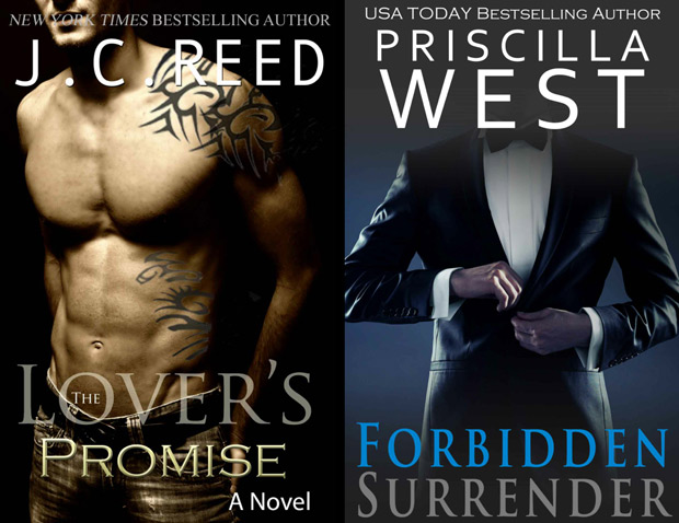
Headless dudes, semi-naked bad boys and billionaires are de rigueur for New Adult romance book covers.
At the top of this blog, I’ve posted a comparison of five covers that use the same image (this was not an image I had considered using, but it’s clearly an evocative image that screams “hot!” – and many authors/designers thought so). All of these covers have merit, and some designers have attempted to set the image apart by changing hair colors, backgrounds and textures – even adding a tattoo. The repetition, however, illustrates a danger of using stock photography. (In fact, there were even more book covers featuring the same image that I didn’t post here.)
I’ve had a taste of this phenomenon myself. I saw the same handsome model who portrays Jack on my Storm Seekers book covers appear in an ad on the same Amazon page as my books. The similarity wasn’t that obvious, since I’ve significantly altered the images, but it was still startling to see them on the same page. And in researching this blog post, I found him on another book cover. I’m not surprised; he’s gorgeous, and stock photos are cheap.
The question is, does it matter if an image is used again and again? Most authors, I think, would like to make a unique impression with their book, unless they consider their fiction disposable. But if the cover is attractive and sells books, who cares?
I care. Being like everyone else bothers me a bit. So for the book covers I’m designing, I’m leaning toward more abstract or people-free images using original photography, rather than stock photos.
The trick for any designer is to pick an image that broadcasts your genre while not looking like everything else – and in the worst case, exactly like something else.
If you are into the New Adult genre, does it matter to you if the cover has a flower on it or an amorous couple? Do you care if you’ve seen the cover image before, or would it be confusing? Once you’re shopping in your favorite literature category, any category, is the description your primary enticement to buy a book?
What do you think?
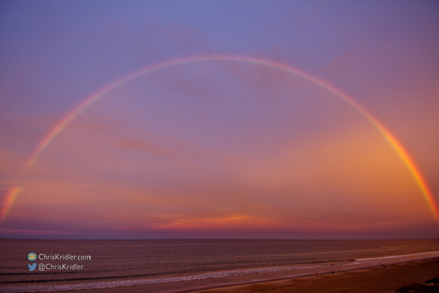
A rainbow glows in the sunset-orange sky at Indialantic, Florida, on Aug. 16, 2014. Photo by Chris Kridler, ChrisKridler.com, SkyDiary.com
May was a historically slow time for tornadoes, and I wasn’t in the Plains for the three-day tornado-mageddon event that produced the Pilger, Nebraska, tornado and others.
Still, I photographed a lot of beautiful storms and skies in Florida and Tornado Alley, and while I did so, I finished my research for “Zap Bang” and published it in September – the third novel in my Storm Seekers trilogy. And even if I didn’t see incredible tornadoes, my characters did!
Here’s a slide show that looks back at 2014’s dramatic skies through photography.
| #NaNoWriMo Tweets |
National Novel Writing Month is about two-thirds over, which means some 400,000 official participants – along with folks like myself who just wanted to test their mettle – are churning out copy toward the stated goal of completing a 50,000-word novel in November. I find participating in this process exhilarating. It really pushes me to write, and as a journalist, I’ve always thrived on deadlines. And I get a sense of fellowship with my fellow writers, who are airing their struggles and words of encouragement online in venues such as Twitter.
If you want to look at all these writers as competition – especially with companies jumping up to sell you publishing services at every turn – you wouldn’t be wrong, either. With up to a million books being published in the United States alone each year, the chances of your voice being heard in the wilderness dwindle all the time. But at least we live in an era when we can press the button and put a book out there without being totally at the mercy of the great publishing machine.
If “it outlasts them all,” you might want it for NaNoWriMo. (Public domain image via Wikimedia Commons)
Struggle or not, I don’t think anyone gets into National Novel Writing Month, or NaNoWriMo, to make money. It’s not easy to write that many words, as a rule. They’re doing it for the challenge and for the love of the written word.
This time, I’m doing it as an experiment, writing in a genre that’s new to me. Maybe it’s because of my casual approach, but I’ve found this romance manuscript to flow more easily than almost anything else I’ve written, and I’ve already surpassed my 50,000 words. I’m aiming for 70,000 and a complete novel by month’s end. I’ll probably publish this book myself, under a pen name, and because I’ve self-published before, I know a lot of work is still ahead of me. But it’s fun to be in there slugging with all the other NaNoWriMo writers this month, fighting the good fight. No matter how crazy the business has become, it’s still about the words on the page.
Ask not for whom the typewriter dings. It dings for thee.
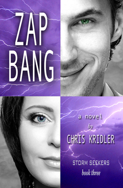
ZAP BANG, book 3 in the Storm Seekers trilogy by Chris Kridler.
This illustration appears on the back cover of “Zap Bang.”
I’d like to thank all the lovely people who shared and Tweeted the launch of my novel “Zap Bang” this past week – so many great friends and indie authors on Facebook and Twitter. I’ve also appreciated the coverage from Florida Today, Florida Book News and Authors and Book Buzz, and the fun interview in Jaimie M. Engle’s writing blog.
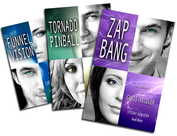
It’s hard to make oneself heard in the noisy world of publishing these days, but I heard the buzz this week! Now I hope more folks will discover the Storm Seekers trilogy over time and get into these storm-chasing adventures the way I have. To that end, “Funnel Vision,” book one, is still on sale this week on Kindle and Nook for 99 cents. You can learn more or buy any of the books via the links on this page.
And – there’s still time to win stuff! The giveaway of the big Storm Seekers Prize Pack ends late Monday evening. Check it out here and enter!
In addition, you can win a paperback of “Zap Bang” on Goodreads. The giveaway ends Sept. 30.

It’s launch day for Zap Bang! That means the third novel in the Storm Seekers trilogy is officially for sale, and I hope you’ll check it out! Here’s what you need to know:
Giveaway: The Storm Seekers Prize Pack Giveaway is under way through Sept. 22. Enter here or on Facebook. The goodies include signed paperbacks, a very cool captured lightning sculpture, a storm T-shirt and more. Via the giveaway, you can Tweet every day to stack up your entries, too.
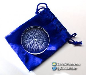
This small captured lightning sculpture is among the goodies in the Storm Seekers giveaway. It was created with a 5 million volt particle accelerator.
Goodreads giveaway: Go to this page on Goodreads to register to win an autographed paperback copy of Zap Bang. The entry period ends Sept. 30.
All about Zap Bang: The sequel to Funnel Vision and Tornado Pinball, Zap Bang concludes the Storm Seekers trilogy with action, drama, humor and romance. Here’s the setup:
For tornado chaser Jack Andreas, an invitation to a lightning study means double the danger. As he sees it, what’s not to love? He’s intrigued by the job and fascinated by pilot Maribeth Lisbon, who must fly a research plane into the zap zone. Maribeth suspects he’s trouble, especially when his charms set off all her alarms. In their way are scheming TV chaser Brad Treat and down-on-his-luck adventurer Aurelius Zane, intent on filming a wedding in front of a twister. The eccentric billionaire who funds the study has a secret agenda. And a mystic with a food truck tests them all. As fearsome storms put them in mortal peril, Jack and Maribeth find their toughest challenge may lie within.
Catch some of the adrenaline in the book trailer:
You might also like to read about the playlist I created as inspiration while I was writing the book. For more details about the books and free sample chapters, visit the books page.
To make it easy, here are links where you can buy Zap Bang:
Amazon: Paperback | Kindle
Barnes & Noble: Paperback | Nook
Also at: iBooks/iTunes | Kobo
So there you go. Zap Bang is in the wild, and a wild, lightning-laced adventure it is. I’ll dearly miss writing about these characters, but I hope you’ll enjoy living in their world as much as I have. Happy chasing!
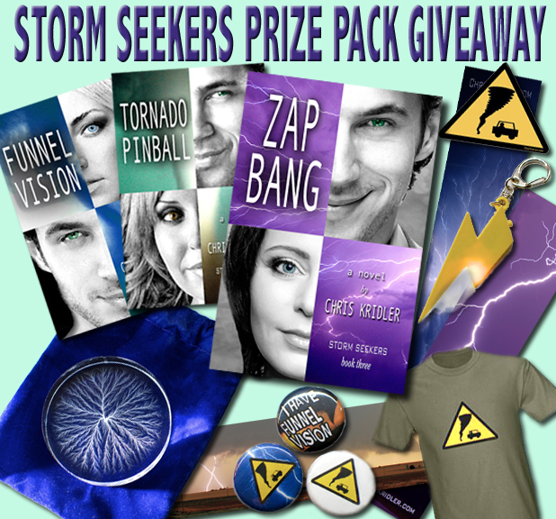
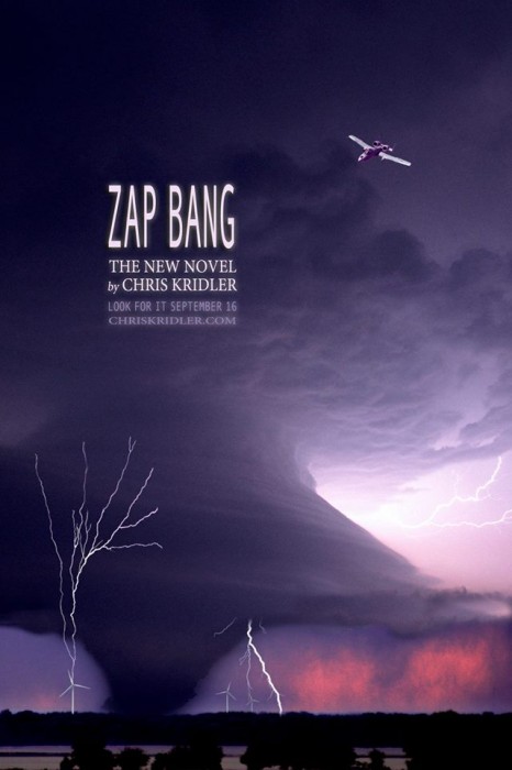
Zap Bang, the third novel in the Storm Seekers trilogy of storm-chasing adventures by Chris Kridler, will be published Sept. 16, and to celebrate, Sky Diary Productions is offering a giveaway! The goodies include:
The captured lightning is completely cool, and you’ll read about it in Zap Bang. The giveaway ends on Sept. 22, so get in your entries now!


.")
.")


